Thursday, February 26, 2009

Record Warmth & High Wildfire Threat:


*** Red Flag Warning for Taylor, Nolan, Jones, Fisher, Mitchell, Scurry, Throckmorton, Haskell, Stonewall, and Knox County from Noon until 6:00 PM this evening. ***

Good Morning from KRBC Meteorologist Chris Whited...

* Record Warmth: Forecast highs will climb today into the lower and middle 90s which is about 20 to 25° above normal for late February. The record high today for Abilene is 89° which was set back in 1917. I do expect we will set a new record today.

* Fire Threat: Gusty southwest winds will blow across the area today bring critial to extreme wildfire danger to the area. As mentioned above a red flag warning is in effect for areas of the Big Country this afternoon and early evening.

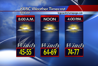
* Cooling Trend Ahead: A decent cold front will move through late tonight and bring much cooler weather for Friday and into the weekend. Temperatures will be about 30° cooler on Friday than forecasted today. Also cool over the weekend with upper 50s and lower 60s.


* Next Week: Get ready for another developing warming trend for next week with highs back in the 70s and 80s. No rain is seen in the extended periods.

* Quick Note: San Angelo NWS will conduct a practice tornado warning drill this morning at 9:30 AM as part of Texas Severe Weather Awareness Week.

Have a nice Thursday...

Wednesday, February 25, 2009

Hot Then Cold Then Warm

From KRBC Chief Meteorologist Randy Turner ....

We (the KRBC Weather Team) have been working on a severe weather special called "Weathering the Storm" to be broadcast in March. I'll let you know the date as soon as we know. We worked on a portion of it today in the studio and had some good fun.

After that, it was time to forecast and what I ended up with, I didn't necessarily like. I didn't like it because there was no rain in the forecast, again, for the next seven days. But, what I did find was this:

Thursday will be hot, around 92 for a high with a westerly wind at 15 to 25.

Thursday Night will be cooler, thanks to a cold front, low near 48. North wind 10 to 20.

Friday will be much cooler than Thursday, about 62 for the high.

Saturday and Sunday highs will be around the 60 mark, with some reinforcing cool air dropping in.

Early next week, a warming trend, with highs back in the 70's by Monday and the 80's Tuesday and Wednesday.

I'll keep looking for rain. Thanks for reading my blog.

Randy

Another Tease Of Summer Weather:


Good Morning from Meteorologist Chris Whited...

* This Is Late Winter? We should normally be sitting in the lower 60s for highs but we sure did get a taste of summer on Tuesday across the area. Abilene officially reached 90° which was close to the record of 91° from 1918. Would you believe Breckenridge was the warmest spot we could find in the Big Country reaching 95°!

* Another Warm Day: Winds will not be so back so temperatures should be a few degrees cooler but still unseasonably warm into the middle and upper 80s. A few high clouds will work in from the west during the day so we should see partly cloudy conditions later in the day. A very mild night tonight with lows into the middle 50s with a few clouds.

* Thursday: Winds will pick back up tomorrow so temperatures will climb back in the lower 90s across the area. We are expecting a cold front overnight Thursday and we normally see a really warm day ahead of a decent front to most spots will be in the lower to middle 90s. I'm forecasting a high tomorrow of 92. (One forecast model (NAM) is going 97!)

* Weekend: Above mentioned cold front will bring cooler air for Friday and the weekend as highs drop back to where they should be in the upper 50s and lower 60s with some chilly nights into the 30s by late weekend.

* Next Week: Get ready for another developing warming trend for next week with highs back in the 70s and 80s. No rain is seen in the extended periods.

* Quick Note: We have a time change coming up on Sunday, March 8th as we go back to Daylight Saving Time. You may recall Congress and the former President Bush extended daylight saving time a few years ago.

Enjoy your Wednesday...

Tuesday, February 24, 2009

Whew, It's Hot !!!

From KRBC Chief Meteorologist Randy Turner ...

If temperatures today are a sign of things to come, I shiver to think how hot it may be this summer around here. Abilene's temperature at 2pm today was 90 degrees, just one degree away from the record of 91 which dates back to 1918. It's entirely possible that we'll tie or perhaps break the record, we'll know by about 5:30pm today when the official report is issued.

In case you are wondering, the normal high for today's date is 63.

The next two days will be close to this warm, with my forecast highs being 87 on Wednesday and 90 on Thursday.

The next cold front is Thursday night which will drop our afternoon highs close to 65 degrees for Friday, very close to normal for this time of year.

Another cold front is due Saturday night which means Sunday, with a high near 60, may turn out to be the coolest day of the next seven.

Rain isn't in my forecast at this time, although one model hinted at bringing showers up from the south Sunday night, although confidence in that is very low at this time. I'll leave the forecast a dry one.

This Is Late Winter?


Good Morning from Meteorologist Chris Whited...

* We should normally be seeing high temperatures into the lower 60s for the end of February but it is going to see like late May or June out there today with highs climbing into the upper 80s and a few spots in the lower 90s today across West Central Texas. High pressure off to our east and a strong low pressure to our west are pulling a strong pressure gradient across the Big Country which simply means windy conditions today. Those south/southwest winds are the reason it's going to be so warm today. A few high clouds are possibly today across the area. Tonight we drop into the lower 50s with a few upper 40s but still breezy.

* Another very warm day tomorrow with middle to upper 80s and still into the lower to middle 80s on Thursday. A cold front will arrive overnight Thursday/early Friday cooling us back into the 60s for highs over the weekend before another slight warming trend early next week.

* Rainfall Outlook: Not Good... We remain about a inch and a half below normal for the year and as you can see above on the graphical rain breakdown over the last several months, not much has happened as far as rain goes since October of last year. All of the area remains under severe stage drought conditons according to the NOAA Climate Data. Extreme drought can be found along the Colorado River in the Heartland.

Have a great day...

Monday, February 23, 2009

Wow, It's Warm !!

From KRBC Chief Meteorologist Randy Turner ....

Several weather stories going on now, none helpful in terms of bring us rain.

First, gusty wind persists Tuesday into Wednesday, leading to yet another Fire Weather Watch Tuesday.

Secondly, unusually warm temperatures are forecast Tuesday, into the middle 80's, thanks to a southwest and westerly wind.

Thirdly, the warmth lingers through Friday.

Whether or not a cold front drops our temperatures this weekend is still a question up in the air, in my view. For now, I'm leaving temperatures warm this weekend with no rain in the forecast.

Warm and Windy Weather This Week

From KRBC Chief Meteorologist Randy Turner ..

As of early Monday morning, temperatures had only dipped to the upper 40's, thanks to a persistent southerly wind overnight.

The big weather stories this week will continue to be the drought, high wildfire danger, gusty wind and warmer than normal temperatures.

Concerning the dry weather, it doesn't appear any rain relief is on the way anytime soon, no rain in my forecast through the next seven days.

Concerning the high wildfire danger, you know the drill. EVERYDAY is a high wildfire danger day this week.

Concerning the gusty wind, areas of low pressure will keep the wind machine cranked on a daily basis much of this week.

Concerning the temperatures, if you like Spring, you'll love this week's temperatures. In the 70's today (Monday) but in the 80's Tuesday through Thursday.

Sunday night I wrote the next cold front was due Thursday night. But new forecast data Monday morning suggests the front may be delayed, and not as strong, arriving on Friday. Even then, temperatures aren't expected to take much of a plunge, back closer to normal highs and lows for this time of year.

I wished I had better news concerning rain, but the dry pattern continues.

Sunday, February 22, 2009

Much Warmer This Week

From KRBC Chief Meteorologist Randy Turner ....

Spring Fever is in the air this week in the Big Country and Heartland. Warm air from the southwest overspreads the area starting with the 70's on Monday with 80's on Tuesday through Thursday.

One cold front this week is expected on Thursday night so Friday will be our coolest day of the week with highs around 60. A warming trend will return for the upcoming weekend.

Rain? I wished I had better news, but I don't. No rain is in my seven day forecast.

Wind? Yes, always, plenty of it this week, especially Monday, Wednesday, Thursday and Friday.

Bottom line - the wildfire danger will persist and temperatures will be 10 to 15 degrees above normal most of the week.

Friday, February 20, 2009

High Wildfire Threat Today:


*** Red Flag Warning in effect from 12:00 PM - 6:00 PM for Taylor, Nolan, Mitchell, Scurry, Fisher, Jones, Callahan, Shackelford, Eastland, Haskell, Throckmorton, Stonewall, Knox, Stephens, Coke, Runnels, Coleman, Brown & Comanche County. (All of the KRBC Viewing Area)

Good Morning from Meteorologist Chris Whited...

* Very high fire threat for the area today as gusty southwest winds will bring one of the ingredients for wildfires across the area. Another factor is it will be a very warm day with highs in the middle 70s, not to mention our dry weather pattern continues.

* A cold front will arrive overnight bringing cooler weather for the weekend with highs in the middle to upper 50s. The winds will still be going but out of the north bringing in the cooler air across our area.

* Next Week: Models the last two days have really been pushing a major warming trend for next week with highs in the upper 70s and some spots touching 80 by mid-week. The pattern remains dry and the fire threat high.

Have a great weekend...

Thursday, February 19, 2009

Cooler & Less Winds Today:


Good Morning from Meteorologist Chris Whited...

* Much cooler day for the Big Country thanks to a weak cold front that slipped in from the north last night. As I blog this just after 4:00 this morning, temperatures are in the 30s across many areas. Daytime highs today will only climb to near 60° in many locations. Another cool night in the area with lows in the middle 30s. Ample sunshine today and clear conditions are expected overnight.

* A quick warming trend for your Friday as well as the winds picking back up out of the southwest so the fire threat will have to be monitored across the area. A decent cold front will move in Friday night and cool us back down over the weekend with highs near 60° once again with mostly sunny conditions.

* Rain Chances: Still not looking good over the next seven days for the area. We really need some rain as severe to extreme drought conditions are in effect across West Central Texas.

Have a great Thursday...

Wednesday, February 18, 2009

Not Much Change In The Forecast:


*** Red Flag Warning in effect for Taylor, Nolan, Mitchell, Callahan, Shackelford, Jones, Fisher, Scurry, Stonewall, Haskell, Throckmorton, Coke, Runnels, Coleman, Brown, Stephens, Eastland & Comanche County for Today ***

Good Morning from Meteorologist Chris Whited...

* Wildfire threat still a concern today across West Central Texas with the dry conditions and northwesterly winds that will stream across the area today. Fire Weather Watch for most areas with a Red Flag Warning in place for the eastern counties.

* Not much change in the weather. The windy conditions will keep us warm today, but as the winds let up we should see some slightly cooler weather work in there for Thursday before the winds pick back up and warm us up again on Friday. A front Friday night should push some cooler weather back into the area over the weekend.

* Looking Ahead: We begin to warm back up early next week with highs back in the upper 60s and lower 70s. There is no rain chance for the area the next seven days.

Enjoy Your Wednesday...

Tuesday, February 17, 2009

Extreme Wildfire Threat Today:


*** Red Flag Warning from 11:00 AM - 7:00 PM for Taylor, Jones, Shackelford, Haskell, Throckmorton, Knox, Fisher, Nolan & Coke ***
*** Lake Wind Advisory from 11:00 AM - 7:00 PM for Taylor, Jones, Nolan, Haskell ***
*** Fire Weather Watch from Wednesday Morning - Wednesday Evening for all of the Big Country, Hearland & Northern Concho Valley ***
Good Morning from Meteorologist Chris Whited...
* Extreme wildfire threat today due to gusty southwest winds and temperatures that will warm quickly into the middle and upper 70s this afternoon. Clouds will begin to decrease as we work into the day and tonight.
* A cold front will arrive this evening and bring slightly cooler air back to the area by Wednesday but the air will modify and warm back up before another cold front on Friday brings another back of cooler air by the weekend. The airmass behind the fronts is not too cold, but it will be cool enough to hold highs in the middle 50s to middle 60s. No rain chances for the next seven days are anticipated.
Enjoy your Tuesday...


Monday, February 16, 2009

Isolated Light Showers Possible

From KRBC Chief Meteorologist Randy Turner ...

The isolated light showers referred to in the title are only around Monday night into Tuesday morning, that's it. I wish I could give you better news, but that's the extent of our rain chances for this week, the way it looks right now.

Looking ahead to Tuesday, it should be considerably warmer, by 25 to 30 degrees, over what we had Monday. Tuesday will also be a very windy day as winds shift into the west during the afternoon and become gusty. This leads to the ever present high wildfire danger.

Windy weather continues into Wednesday as winds shift to the northwest, then to the north behind a front. Wednesday temperatures should be in the 60's but Thursday will be different.

Highs Thursday are forecast only in the 50's. Friday is a brief warming trend back to the 60's but Saturday and Sunday look cooler, similar to last weekend, highs forecast in the 50's.

Freezing temperatures are forecast overnight on Wednesday night and Saturday night so your plants aren't out of danger yet.

I think we still have plenty more shots of cold to go this winter.

Cloudy Start To The Week:


Good Morning from Meteorologist Chris Whited...
* Cloud cover continues to stream along the subtropical jet stream out of the Pacific Ocean, across Northern Mexico and into West Texas and the Big Country this morning. Clouds will stick around all day and into tonight as well. There may be enough moisture to squeeze out an isolated shower in spots but it looks like most of us will be dry today. Temperatures hold in the lower to middle 50s and tonight we only dip into the upper 40s.
* Wildfire Threat: Winds will be on the increase later today and especially tomorrow ahead of a cold front that will move through Texas in the afternoon. We'll have a high wildfire danger thanks to the winds tomorrow. Remember, just about all the counties in our viewing area are under a burn ban.
* Rest of the Week: Windy and Warm Tuesday with 70s before the front sweeps across and the rest of the week going into the weekend looks mostly sunny to partly cloudy with highs in the middle 50s to middle 60s and overnight lows into the 50s. The forecast pattern looks to remain dry.
Have a great Monday...

Sunday, February 15, 2009

Isolated Showers Possible Monday

From KRBC Chief Meteorologist Randy Turner ...

Skies will remain cloudy through Monday and much of Tuesday. We have a slight chance for light showers developing Monday and Monday night as a weak energy source traverses our area. Don't expect much. Most will miss out entirely.

Temperatures will be up and down this week. Monday is cool with highs in the 50's. Tuesday is probably the warmest day of the week as we shoot up to the middle 70's. Wednesday is pleasant, in the 60's, but Thursday is cold again, in the 50's. The upcoming weekend shouldn't be too bad, not as cold as the weekend we just finished.

Besides the slight chance for rain Monday, the chance for rain doesn't look good and a dry forecast is anticipated Tuesday through Sunday.

Fire weather will increase Tuesday with gusty wind and warm and dry conditions.

Don't forget Storm Spotter Training, coming up this Saturday, February 21st, at Abilene Christian University, starting at 9:00am. This year, it will be a much shorter day for spotters. We'll try to finish up everything by 1pm and call it a day. Basic and advanced training will be held in the morning and we will have a storm chaser speak to the group. This is all free and open to everyone to attend. Storm spotters who routinely provide safety information are urged to attend and brush up, just in time for the Spring storm season. I'll see you there !

Randy

Friday, February 13, 2009

Front Arrives Today:


Good Morning from Meteorologist Chris Whited...

* From the NWS/San Angelo:

A relatively quiet weather pattern is indicated for our region during the next 7 days. Considerable high cloudiness associated with southern stream upper jet is overspreading our region. Low-level moisture transport is bringing low clouds into the southern third of our counties. The cloudiness is limiting the radiational cooling and fog development looks unlikely. Thus have removed fog from the forecast this morning.

A weak and dry cold front will drop South across West Central Ttexas later today. A reinforcing cold front will push down across our region on Sunday. This should help to keep highs cooler than what we have seen in recent days. Early next week an upper low and trough off the California coast is progged to open into a wave and eject east across the central rockies and into the Central Plains by Tuesday afternoon.

With this setup the surface low is progged to develop in the lee of the Colorado Rockies by Tuesday morning with a surface trough extending south along the Texas/New Mexico border. Surface trough/dryline progged to advance east across west central texas on tuesday. This would bring elevated fire weather conditions with intrusion of much drier air and gusty southwest to west winds. With such weak surface and upper support indicated for our area Monday/Monday night have removed the pops from our eastern counties. At this point looks like a dry forecast into the middle of next week.

Thursday, February 12, 2009

Ho-Hum !!

From KRBC Chief Meteorologist Randy Turner ...

Wind is the story again today into tomorrow, not as high as we saw earlier this week, but breezy nonetheless.

A cold front late in the day Friday will drop our temperatures to around freezing by early Saturday morning. Temperatures this weekend will be cooler than they are now, highs middle 50's on Saturday and near 60 on Sunday.

There is one slim glimmer of hope for rain and that comes with a weak system passing through the area Monday night. Honestly, chances don't look good. I wished I had better news concerning rain, but it just looks dry for the next week.

So, as the title suggests, a rather ho-hum type weather pattern right now. Warm days, then cool days, back to warm to start next week.

Take care !!

Wednesday, February 11, 2009

Warm and Breezy Thursday

From KRBC Chief Meteorologist Randy Turner ...

Mostly clear skies prevail Wednesday night and Thursday across the KRBC viewing area.

We'll see temperatures climb into the low 70's on Thursday but the wind will also increase during the afternoon, from the south, at speeds between 10 and 20 with a few higher gusts.

For those of you making plans for the weekend, dry weather is in store. Friday's high in the middle 60's will be followed by slightly cooler air this weekend, around 60 Saturday and mid 50's to 60 on Sunday.

I'm still including a 20 percent chance for rain and temperatures in the 50's for Monday.

Fire danger remains a concern.

A Quiet Weather Day...


Good Morning from Meteorologist Chris Whited...
* Winds are starting to let up this morning after a crazy evening yesterday with severe weather in the eastern areas and blowing dust across the rest of the Big Country. This morning it's still a bit breezy but the winds will subside later this morning, generally back down in the 5-10 mile per hour range. According to the NWS data, Abilene had a peak wind gust yesterday of 52 mph and so far since midnight we say a wind gust to 38 miles per hour.
* Sunny and a bit cooler today with highs back in the middle to upper 60s and quiet tonight with lows down in the lower 40s. Tomorrow looks nice but warming back up into the middel 70s as the wind picks back up from the south.
* A cold front will move into the Big Country Friday evening and bring much cooler weather for the Valentines Day weekend with highs on Saturday only into the 50s and lows at night around freezing. Looks like our next small rain chance will be overnight Monday/early Tuesday.
Enjoy your Wednesday...

Tuesday, February 10, 2009

Extreme Fire Threat & Severe Storms Possible Today:


*** Red Flag Warning for Taylor, Nolan, Jones, Fisher, Coke & Runnels County from 1:00 PM - 9:00 PM ***

*** Wind Advisory for Taylor, Nolan, Jones, Fisher, Coke, Runnels, Haskell & Throckmorton County from 11:00 AM - 9:00 PM ***

*** High Wind Warning for Mitchell & Scurry County until 9:00 PM ***

*** Blowing Dust Advisory for Mitchell & Scurry County until 9:00 PM ***

*** High Wind Watch for Stonewall County until 9:00 PM ***

*** Severe Weather: Slight Risk Issued by SPC For the Eastern Big Country and Eastern Heartland. Strong to Severe Storms Possible along the dryline this afternoon and evening. Area roughly along and east of U.S. Highway 277, including the U.S. 183 & 283 Corridor and the I-20 Corridor east of Abilene. ***

Good Morning from Meteorologist Chris Whited....

* I think the advisories above just about cover it for today. Extremely high fire danger across the area this afternoon behind a dryline that will advance eastward today. Along and ahead of the dryline, isolated strong to severe thunderstorms are expected to develop. Also we will be dealing with blowing dust at times today to make matters worse.

* Please see the KRBC Forecast: Tuesday AM video forecast for more detail on the events today and of course stay with KRBC News and BigCountryHomepage.Com during the day for breaking weather news.

Monday, February 09, 2009

Here Comes More Wind !!

From KRBC Chief Meteorologist Randy Turner ...

After mostly light rainfall through the area early this morning, we return to our dry and windy ways. Another fast moving upper level low will swing across the area Tuesday. It might possibly create a storm or two across our eastern viewing area but doubtful. It will, however, produce much wind, especially during the afternoon hours. Expect wind gusts between 30 and 40 to be common which increases the threat for wildfires once again. The wind should die down Tuesday night, remain fairly tranquil Wednesday, but increase once again Thursday and remain gusty through the upcoming weekend.

Chances for more rain over the next seven days are slim to none. Temperatures will be a little above normal for this time of year.

Wet Morning, Dry Afternoon


Good Moring from the KRBC Triple Doppler Weatherlab...

* The front has pushed through the forecast area this morning with a sunny day is on tap for this afternoon with afternoon temperatures around 70 degrees and breezy conditions over the area. Next upper level system is digging down the west coast this morning and will be over New Mexico by early tomorrow. Tuesday will be warm and windy ahead of the next system with temperatures in the upper 7os. The windy conditions combined with very dry air over the western half of the cwa will create a fire danger tuesday afternoon. As the second upper level system moves over the panhandle area late Tuesday with another cold front will push through the area during the day. Moisture return back into the forecast area will be limited. The best chance of shower activity on Tuesday will be over our extreme eastern counties tuesday evening where the best moisture will be located.

* An approaching strong upper level disturbance moving into new mexico will push a dryline into western portions of the forecast area on tuesday. A combination of warm temperatures, dry air and gusty winds behind the dryline may bring critical fire weather conditions to roughly the western half of west central Texas Tuesday afternoon.

Sunday, February 08, 2009

Storms Sunday Night / Fire Watch Tuesday

From KRBC Chief Meteorologist Randy Turner ...

Hope for rain Sunday night and Monday morning will be replaced by the same scenario we've grown accustomed to, wildfire danger by Tuesday.

Thunderstorms look likely from late Sunday night through the overnight and early morning hours of Monday, followed by clearing skies.

Another fast moving upper level disturbance will crank the wind from the west Tuesday, drying out the area causing a rise in the fire danger. Don't be surprised to see dust blow into the area Tuesday. The following statement was released by the National Weather Service Sunday afternoon, regarding the Tuesday wildfire potential.


...CRITICAL FIRE WEATHER CONDITIONS ARE POSSIBLE TUESDAY AFTERNOON...

.WITH THE APPROACH OF A STRONG UPPER LEVEL DISTURBANCE FROM NEW
MEXICO...A DRYLINE WILL ADVANCE EAST ACROSS PARTS OF WEST CENTRAL
TEXAS ON TUESDAY.

A COMBINATION OF WARM TEMPERATURES...DRY AIR AND GUSTY WINDS BEHIND THE DRYLINE MAY BRING CRITICAL FIRE WEATHER CONDITIONS TO ROUGHLY THE WESTERN HALF OF WEST CENTRAL TEXAS TUESDAY AFTERNOON.

GUSTY SOUTH TO SOUTHWEST WINDS OF 20 TO 25 MPH AT THE 20 FT LEVEL
ARE FORECAST TO OCCUR TUESDAY AFTERNOON. RELATIVE HUMIDITY VALUES
ARE EXPECTED TO DROP BELOW 20 PERCENT.

THE COMBINATION OF THESE FACTORS WILL ELEVATE THE FIRE WEATHER DANGER TO CRITICAL LEVELS. A FIRE WEATHER WATCH MEANS THAT CRITICAL FIRE WEATHER CONDITIONS ARE FORECAST TO OCCUR. LISTEN FOR LATER FORECASTS AND POSSIBLE RED FLAG WARNINGS.

Strong to Severe Storms Tonight:

HAZARDOUS WEATHER OUTLOOK
NATIONAL WEATHER SERVICE SAN ANGELO TX
724 AM CST SUN FEB 8 2009

THIS HAZARDOUS WEATHER OUTLOOK IS FOR PORTIONS OF WEST CENTRAL
TEXAS.

.DAY ONE...TODAY AND TONIGHT

A LINE OF THUNDERSTORMS IS EXPECTED TO PUSH ACROSS WEST CENTRAL TEXAS TONIGHT...AS A STRONG UPPER LEVEL STORM SYSTEM APPROACHES THE AREA. THESE STORMS WILL LIKELY DEVELOP ACROSS WEST TEXAS SUNDAY AFTERNOON...AND PUSH INTO WEST CENTRAL TEXAS DURING THE LATE EVENING AND EARLY MORNING TIME PERIOD. A FEW OF THESE STORMS MAY BRIEFLY REACH SEVERE LEVELS...MAINLY ALONG AND WEST OF A HASKELL TO SWEETWATER TO SAN ANGELO LINE. DAMAGING WINDS WILL BE THE PRIMARY SEVERE WEATHER THREAT.

.DAYS TWO THROUGH SEVEN...MONDAY THROUGH SATURDAY

THE LINE OF STORMS WILL LIKELY BE EXITING WEST CENTRAL TEXAS BY SUNRISE WEDNESDAY MORNING. A SECOND STRONG UPPER LEVEL DISTURBANCE AND DRYLINE WILL ENTER THE REGION FROM THE WEST ON TUESDAY. THIS WILL BRING A SLIGHT CHANCE OF THUNDERSTORMS TO EASTERN SECTIONS OF WEST CENTRAL TEXAS ON TUESDAY AFTERNOON. IN ADDITION...STRONG WEST WINDS WILL FOLLOW THIS SYSTEM BEHIND THE DRYLINE. AREAS THAT DO NOT SEE SIGNIFICANT RAINFALL TONIGHT MAY SEE HAZARDOUS FIRE WEATHER CONDITIONS ON TUESDAY AS WELL.

.SPOTTER INFORMATION STATEMENT...

SPOTTER ACTIVATION MAY BE REQUESTED ACROSS THE WESTERN BIG COUNTRY
AND THE WESTERN CONCHO VALLEY SUNDAY EVENING.

Saturday, February 07, 2009

Strong Storms Possible Sunday Night:

HAZARDOUS WEATHER OUTLOOK
NATIONAL WEATHER SERVICE SAN ANGELO TX
711 AM CST SAT FEB 7 2009

THIS HAZARDOUS WEATHER OUTLOOK IS FOR PORTIONS OF WEST CENTRAL
TEXAS.

.DAY ONE...TODAY AND TONIGHT

ELEVATED FIRE WEATHER CONDITIONS WILL CONTINUE FOR TODAY DUE TO
STRONG SOUTHERLY WINDS AND THE RECENT DRY SPELL. OUTDOOR ACTIVITIES THAT COULD RESULT IN THE GENERATION OF A FIRE SHOULD BE AVOIDED.

.DAYS TWO THROUGH SEVEN...SUNDAY THROUGH FRIDAY

THERE IS A SLIGHT RISK OF SEVERE THUNDERSTORMS ACROSS PORTIONS OF WEST CENTRAL TX MAINLY WEST OF AN ABILENE TO SAN ANGELO LINE SUNDAY EVENING. THE MAIN POTENTIAL HAZARD WILL BE DAMAGING WINDS...WITH MARGINALLY SEVERE HAIL BEING SECONDARY. A POTENT UPPER LEVEL STORM SYSTEM IS FORECAST TO EJECT NORTHEAST ACROSS THE SOUTHERN PLAINS SUNDAY NIGHT AND WILL INTERACT WITH LOW LEVEL MOISTURE IN PLACE OVER THE REGION TO PRODUCE A LINE OF SHOWERS AND THUNDERSTORMS...SOME OF WHICH COULD BECOME SEVERE...THAT WILL SWEEP ACROSS WEST CENTRAL TX. WIDESPREAD SEVERE WEATHER IS NOT ANTICIPATED DUE TO A LACK OF INSTABILITY.

THERE IS ANOTHER RISK OF SEVERE WEATHER TUESDAY AND TUESDAY NIGHT ACROSS EASTERN PORTIONS OF WEST CENTRAL TX. THE POTENTIAL IS THERE FOR A MORE SIGNIFICANT SEVERE WEATHER THREAT AS YET ANOTHER STRONG UPPER LEVEL STORM SYSTEM MOVES ACROSS THE SOUTHERN PLAINS. THERE WILL BE MORE INSTABILITY FOR THIS SYSTEM TO WORK WITH...SO THIS SITUATION BEARS WATCHING AS THIS TIME NEARS.

.SPOTTER INFORMATION STATEMENT...

SPOTTER ACTIVATION WILL NOT BE NEEDED TODAY OR TONIGHT.

Friday, February 06, 2009

Rain Chances On The Horizon:


Good Morning from Meteorologist Chris Whited...

* Warming up and very windy during the day today with south winds ranging anywhere between 20-35 miles per hour. Highs will climb into the middle and upper 70s today. Sky conditions will be mostly sunny but clouds will begin to increase tonight as we drop into the middle 50s.

* Rain Chances: Still looks like a line of thunderstorms will sweep through the Big Country late Sunday night and early Monday morning, which will probably bring us the best rain chances we've had since all the way back in October. The SPC has a slight risk for severe weather outlined for Sunday for an area just to our west from Midland-Odessa to about Dalhart. The line of storms could be strong to severe as it moves through our area...the primary threat being winds and hail. Stay with us over the weekend as we monitor the event. There is also another chance for rain, although slight, for late Tuesdy and into the day on Wednesday.

Have a great weekend...

Thursday, February 05, 2009

Wind Woes / Rain Hopes

From KRBC Chief Meteorologist Randy Turner ...

The gusty wind isn't going anywhere, anytime soon. We'll experience gusty wind for the next week or so as systems approach and pass through our area.

We are entering a more progressive weather pattern allow rain to enter the forecast. On Friday and Saturday, gusty south wind helps return Gulf moisture to the area. By late Sunday, as a vigorous upper level storm moves our way, a squall line of thunderstorms is expected to develop and move through our area. This will most likely occur Sunday night into early Monday morning. A few of the storms could become severe.

Another upper level storm may provide a chance for thunderstorms Tuesday night or Wednesday, as it follows the first storm.

Friday and Saturday: Very windy. Morning low clouds, then mostly sunny skies. Highs 71-75 both days. South wind 20 to 30 with higher gusts. Overnight lows in the low 50's.

Sunday: Mostly cloudy, continued windy, high 68 with a 20% chance for late day storms.

Sunday Night: Thunderstorms likely, some severe. Low near 52.

Monday: Morning thunderstorms, then partly cloudy and windy. High 68.

Tuesday: Partly cloudy and windy, high 70 with a cold front approaching late.

Warm & Windy Today:


Good Morning from Meteorologist Chris Whited...

* Warming up and very windy during the day today with south winds ranging anywhere between 20-30 miles per hour. Highs will climb into the lower 70s today and we should see a few high clouds working in the area later today.

* Fire Danger: The fire threat remains elevated thanks to the severe drought and the very windy conditions the next few days. Moisture will return from the southeast raising the relative humidity values before our next rain event. As of today, the NWS says they will not issue any advisories due to relative humidity values above
20% today, but having said that the threat is still high. All counties in the KRBC viewing area are under a burn ban.

* Warming Trend: Daytime highs in the 70s will be paramount as we head into Friday and the weekend with partly cloudy conditions. Nice weekend for outdoor activities.

* Rain Chances: Still looks like a line of thunderstorms will sweep through the Big Country late Sunday night and early Monday morning, which will probably bring us the best rain chances we've had since all the way back in October. There is also another chance for rain, although slight, for late Tuesday and into the day on Wednesday.

Have a great Thursday...

Wednesday, February 04, 2009

Window of Opportunity for Rain

From KRBC Chief Meteorologist Randy Turner ...

Welcome to the blog, dry most of the time, wet every once in a while.

What we have coming up is a three day stretch of dry and warm weather - Thursday through Saturday, the gusty south wind will dominate keeping temperatures higher than normal but also increasing the wildfire danger.

We're watching a large upper level low pressure center, located off the west coast of California Wednesday evening. It will move east and bring us a chance for rain by Sunday.

It appears our "window of opportunity" for rain will be between Sunday afternoon and Monday morning, most likely overnight Sunday night. Some showers are possible along with a line of thunderstorms. It will be a brief opportunity, but hopefully some, if not all, of us will benefit from some rain. Amounts won't likely be impressive.

Temperatures trend above normal in the 70's Thursday, Friday and Saturday.
Overnight lows above normal around 50.

A Bit Cooler Today, Warmer & Windy Tomorrow:


* Another nice day across the area today, although it will be a few degrees cooler thanks to the front that moved through late yesterday afternoon across the Big Country. Highs today will reach the lower 60s and we'll cool down to only the lower 40s tonight. Winds will begin to pick up tonight as well.

* Fire Danger: Winds will really begin to pick up the next few days as we also start a warming trend. The fire threat remains elevated thanks to the severe drought and also looks to increase. By late weekend moisture will return raising the relative humidity values before our next rain event.

* Warming Trend: Daytime highs in the 70s will be paramount as we head into Friday and the weekend with partly cloudy conditions. Nice weekend for outdoor activities.

* Rain Chances: Still looks like a line of thunderstorms will sweep through the Big Country late Sunday night and early Monday morning, which will probably bring us the best rain chances we've had since all the way back in October. Instability and dynamics are not looking so impressive this morning on the threat of severe weather, but having said that we could see a strong storm or two. Stay tuned as we get closer to the event and get a better feel for the threat.

Have a great Wednesday...

Tuesday, February 03, 2009

A Nice Day Ahead:


Good Morning from Meteorologist Chris Whited...

* A very nice day ahead with plenty of sunshine and highs in the upper 60s across the Big Country. A cold front moved through late this evening and overnight work a slightly cooler air mass works into Texas.Highs tomorrow will be about 10 degrees cooler around 60 in most spots.

* Warming Trend: Daytime highs in the 70s will be paramount as we head into Friday and the weekend with partly cloudy conditions. Nice weekend for outdoor activities.
* Fire Danger: The fire threat remains elevated thanks to the severe drought and also looks to increase as we get toward the weekend with gusty winds from the southwest that warm the daytime highs into the 70s. Late weekend returns raising the relative humidity values.
* Rain Chances: Model runs this morning are looking better for a chance of rain late Sunday and into Monday morning. Last night and this mornings models are hinting at a possible squall line moving through the area which would bring us a little better rain chance but then again looking at the parameters right now for right now, we have some dynamics in place for possible strong storms. Something to keep an eye on, otherwise the big story here is some rain!

Enjoy your Tuesday...

Monday, February 02, 2009

Rain on the Horizon

From KRBC Chief Meteorologist Randy Turner ....

A blocking ridge of high pressure rules the weather stage through the rest of this week. But once the high breaks down and drifts to the east this weekend, it allows for an area of low pressure to set up shop and bring us a chance for rain from the southwest.

The pattern itself is pretty similar to what happened this time last week when the high departed and the moisture came out of the southwest, putting us in an ice storm. This time, however, cold air isn't in the equation.

It's still too early to forecast rainfall amounts and percentages. I've put a 20% chance in for late Sunday and a 30% chance for Monday, so we are still about a week away. As the days go by, hopefully I can increase those percentages.

Drought continues through Saturday, wildfire danger remains high, especially when the winds increase Thursday and remain gusty through Saturday. Most counties in our area are under Burn Bans.

Monday Night: Clear and cold, 29.
Tuesday: Sunny and mild, high 64 with a weak front shifting winds to the north in the afternoon.
Tuesday Night: Clear and 32.
Wednesday: Sunny and 62.
Thursday: Sunny and windy, 68.
Friday: Partly cloudy and windy, 73.
Saturday: Partly cloudy and windy, 73.
Sunday: Becoming mostly cloudy, 20% chance for late day showers, high 65.
Monday: Mostly cloudy, 30% chance for thunderstorms, high around 60.

Six More Weeks Of Winter?


Good Morning from Meteorologist Chris Whited...

* Today is Groundhog Day so the question is what can we expect? An end to winter early or six more weeks of the cold stuff? We'll its hard to say because we have a variety of cold and warm in my forecast package for the week ahead. I'm not too keen on the predictions and even more less since I've lived in Texas on and off for three years. We have such a unique weather pattern in this area. We had 80s last month at one point only to end the month with an ice storm, so its hard to say what will happen.

* Getting Back To Business: The cold front moved through late yesterday and last night and continues to move southward as a cooler air mass works into Texas. Highs today will be about 10 degrees cooler than yesterday, mainly into the upper 50s with ample sunshine. Winds will slowly shift tonight and tomorrow which will start a slow warming trend for the area. By Tuesday, highs will be back into the 60s across the Big Country.

* Down The Road: Warm weather fans will like the forecast as we get closer to the end of the week with highs in the upper 60s and widespead 70s over the upcoming weekend. The forecast for this period looks to be partly cloudy.

* Rain Chances: Not good for the week ahead but moisture will be on the increase by late week and I've introduced a slight chance in my forecast package at the end of the forecast period around Sunday with a better chance next Monday based on the forecast model runs.

* Fire Danger: Will remain elevated or high this week but will relax some toward the weekend as that moisture returns raising the relative humidity values.

Have a great Monday...

Sunday, February 01, 2009

Familiar Weather Pattern Returns

From KRBC Chief Meteorologist Randy Turner ....

One thing about this overall weather pattern we are stuck in for now - even though there are times when systems come our way, more often as not, the weather tends to return to a familiar pattern. Unfortunately, that pattern has been a dry northwest flow most of the time, dry cold fronts dropping in from the north.

This week, that pattern is back - but if our forecast models are correct, early next week a slight chance for rain returns to the area.

Until then, be safe, no outside burning.

Temperatures will be around normal Monday, 5 degrees above normal Tuesday and Wednesday then 10 to 15 degrees above normal Thursday. By Friday and Saturday, temperatures warm to 15 to 20 degrees above normal before the next cold front arrives late Saturday or early Sunday.

I'm hoping that an upper level low spins our way from the southwest early next week to bring a chance for rain - we'll leave the chance as slight for now.

Have a great week !!!

Blog Archive