Friday, December 04, 2009

KRBC Weather Alert - Winter Weather Advisory


From the KRBC Weather Lab:

URGENT - WINTER WEATHER MESSAGE
NATIONAL WEATHER SERVICE SAN ANGELO TX
302 PM CST THU DEC 3 2009

...SNOW EXPECTED ACROSS WEST CENTRAL TEXAS TOMORROW MORNING...

.AN UPPER-LEVEL STORM SYSTEM WILL MOVE INTO WEST TEXAS LATER TONIGHT AND BRING THE POSSIBILITY FOR SNOW TO WEST CENTRAL TEXAS. LOOK FOR SNOW TO BEGIN ACROSS WEST CENTRAL TEXAS MAINLY AFTER MIDNIGHT CST TONIGHT. WITH SURFACE TEMPERATURES FALLING BELOW THE FREEZING MARK ACROSS WEST CENTRAL TEXAS EARLY THIS EVENING...EXPECT ANY PRECIPITATION THIS SYSTEM PRODUCES TO FALL AS SNOW.

...WINTER WEATHER ADVISORY IN EFFECT FROM 6 AM TO NOON CST FRIDAY...

THE NATIONAL WEATHER SERVICE IN SAN ANGELO HAS ISSUED A WINTER WEATHER ADVISORY FOR SNOW...WHICH IS IN EFFECT FROM 6 AM TO NOON CST FRIDAY.

EXPECT LIGHT SNOW TO INITIALLY DEVELOP THIS EVENING...MAINLY WEST OF A HASKELL...TO SAN ANGELO...TO OZONA LINE. BETWEEN 6 AM CST AND NOON CST TOMORROW AND FOR LOCATIONS MAINLY ALONG AND SOUTH OF INTERSTATE 20...BRIEF MODERATE TO HEAVY SNOWFALL IS POSSIBLE. THUS...ACCUMULATIONS RANGING FROM ONE HALF TO ONE INCH ARE POSSIBLE. IN ADDITION...SOME LOCATIONS ACROSS THIS AREA MAY HAVE HIGHER ACCUMULATIONS.

PRECAUTIONARY/PREPAREDNESS ACTIONS...

A WINTER WEATHER ADVISORY MEANS THAT PERIODS OF SNOW MAY CAUSE TRAVEL DIFFICULTIES. BE PREPARED FOR SLIPPERY ROADS AND LIMITED VISIBILITIES. ALSO...USE CAUTION WHILE DRIVING.

* Twitter Alerts: You can follow us on twitter anytime for weather updates, especially during the threat of severe or winter weather events affecting the Big Country by visiting the KRBC Weather Twitter. You can also check out news updates from KRBC on twitter also by visiting the Big Country Homepage Twitter

Stay tuned to KRBC for the latest weather information...

Thursday, December 03, 2009

Snow Expected - Very Cold Friday Night - Warming This Weekend

From KRBC Chief Meteorologist Randy Turner ... 8:45pm Thursday night

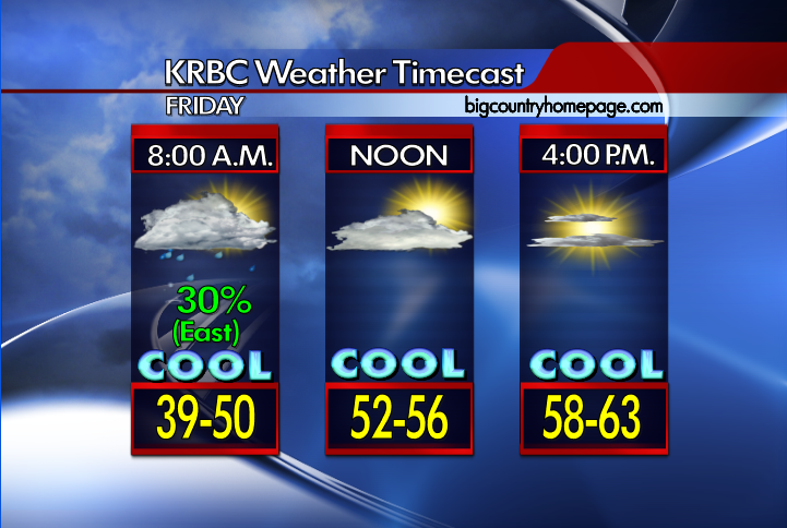
A complex weather situation was taking shape late Thursday night. An upper level storm system was moving out of New Mexico into West Texas. Snow is expected in Abilene, but the heaviest snow may well stay south of Abilene. Snowfall totals of 1 to 3 inches are forecast across the Big Country. Lightest around Abilene, heaviest toward San Angelo, Ballinger, Coleman and Brownwood. Wherever bands of snow set up, isolated amounts greater than 3 inches are possible.

A Winter Weather Advisory will be in effect for Nolan, Taylor, Callahan, Coke, Runnels, Coleman, Brown, Comanche and Mills counties from early Friday morning through the noon hour.

The system will move northwest to southeast. Areas along and either side of a line from Midland to San Angelo to Austin have a good chance at a Winter Wonderland.

The Big Country will see the biggest impact from the storm around sunrise Friday through the mid afternoon hours, then it's over.

Primary impacts will be travel problems from the snow which may also become a sheet of ice due to traffic. Temperatures are likely going to stay around freezing at their highest Friday, limiting any melting. This will further cause driving issues Friday night and Saturday morning as temperatures drop to near 20. Temperatures warm above freezing on Saturday afternoon.

A slow warming trend is forecast Sunday through early next week with no precipitation.

KRBC Weather Alert - Winter Weather Advisory


From the KRBC Weather Lab:

URGENT - WINTER WEATHER MESSAGE
NATIONAL WEATHER SERVICE SAN ANGELO TX
302 PM CST THU DEC 3 2009

...SNOW EXPECTED ACROSS WEST CENTRAL TEXAS TOMORROW MORNING...

.AN UPPER-LEVEL STORM SYSTEM WILL MOVE INTO WEST TEXAS LATER TONIGHT AND BRING THE POSSIBILITY FOR SNOW TO WEST CENTRAL TEXAS. LOOK FOR SNOW TO BEGIN ACROSS WEST CENTRAL TEXAS MAINLY AFTER MIDNIGHT CST TONIGHT. WITH SURFACE TEMPERATURES FALLING BELOW THE FREEZING MARK ACROSS WEST CENTRAL TEXAS EARLY THIS EVENING...EXPECT ANY PRECIPITATION THIS SYSTEM PRODUCES TO FALL AS SNOW.

...WINTER WEATHER ADVISORY IN EFFECT FROM 6 AM TO NOON CST FRIDAY...

THE NATIONAL WEATHER SERVICE IN SAN ANGELO HAS ISSUED A WINTER WEATHER ADVISORY FOR SNOW...WHICH IS IN EFFECT FROM 6 AM TO NOON CST FRIDAY.

EXPECT LIGHT SNOW TO INITIALLY DEVELOP THIS EVENING...MAINLY WEST OF A HASKELL...TO SAN ANGELO...TO OZONA LINE. BETWEEN 6 AM CST AND NOON CST TOMORROW AND FOR LOCATIONS MAINLY ALONG AND SOUTH OF INTERSTATE 20...BRIEF MODERATE TO HEAVY SNOWFALL IS POSSIBLE. THUS...ACCUMULATIONS RANGING FROM ONE HALF TO ONE INCH ARE POSSIBLE. IN ADDITION...SOME LOCATIONS ACROSS THIS AREA MAY HAVE HIGHER ACCUMULATIONS.

PRECAUTIONARY/PREPAREDNESS ACTIONS...

A WINTER WEATHER ADVISORY MEANS THAT PERIODS OF SNOW MAY CAUSE TRAVEL DIFFICULTIES. BE PREPARED FOR SLIPPERY ROADS AND LIMITED VISIBILITIES. ALSO...USE CAUTION WHILE DRIVING.

* Twitter Alerts: You can follow us on twitter anytime for weather updates, especially during the threat of severe or winter weather events affecting the Big Country by visiting the KRBC Weather Twitter. You can also check out news updates from KRBC on twitter also by visiting the Big Country Homepage Twitter

Stay tuned to KRBC for the latest weather information...

Next Winter Storm Arrives Late Tonight:


Good Morning from Meteorologist Chris Whited...

* A very cold start this morning with temperatures ranging between 25-30° for most of us with a partly cloudy sky. Be alerted that there could be some patches of ice on the roads where there is still a little water left over from the melted snow/wintry mix/cold rain from yesterday. Clouds will continue to increase today ahead of the next winter storm for us. Highs today will mostly be in the upper 30s, although a few spots will creep into the the very low 40s. Very cold tonight with lower 20s and of course our snow developing and falling after midnight. The rest of the blog this morning will update the storm and the impacts on us here in the KRBC viewing area. This information was put of from the National Weather Service in San Angelo early this morning in a special weather statement on the event.

* With cold air already in place an approaching upper level storm system will bring a good chance of snow to all of West Central Texas. It appears the snow will start across the northwest Big Country (northwest of Abilene) after midnight Thursday night and then spread across the remainder of West Central Texas during the daylight hours on Friday. although the amount of moisture remains uncertain and it appears that an inch or two of snow accumulation will be possible across most of West Central Texas by the time the snow ends Friday evening. In addition to the threat of snow very cold temperatures are possible Saturday morning. If skies clear as expected behind the storm system temperatures will fall rapidly perhaps reaching into the teens across parts of the area.

* Roadways Tonight/Friday Morning: Given the cold conditions seen the last few days temperatures on area roadways have likely cooled to the point where some of the snow may create icy spots on area roadways.

* Winter Outlook: The Climate Prediction Center indicates a moderate El Niño pattern is taking shape and will bring West Central Texas a wetter pattern for the winter months. There is also a chance for increased winter precipitation depending on temperature trends. Data suggests equal chances of above or below normal temperatures, so more than likely the numbers will remain near normal for this time of year.

* Drought Information: For the lastest drought information for the state of Texas please visit the U.S Drought Monitor website by clicking here. The data is updated by the government every Thursday morning around 7:30 AM.

* Join us on television this morning for the latest on your forecast as well as news from around Abilene & the Big Country on KRBC's Abilene Today starting at 6:00 AM and on Abilene Midday later this morning at 11:30 AM. More news and weather coverage continues this afternoon at 5:00 and tonight 6:00 and 10:00 PM on KRBC.

* Twitter: You can follow us on twitter anytime for quick weather updates, especially during severe weather and winter weather events affecting the Big Country by visiting the KRBC Weather Twitter. You can also check out news updates from KRBC via twitter also by visiting the Big Country Homepage Twitter.

Stay tuned to KRBC for the latest winter weather information. Enjoy your Thursday...

Wednesday, December 02, 2009

One Storm Departs, Another Heads Our Way:


Good Morning from Meteorologist Chris Whited...

* Light snow and wintry mix will continue this morning as the upper level low drifts out of the area. The precipitation should be out of here by midday with clouds sticking around most of the remainder of the day before slowly breaking up overnight. So far this morning we've seen anywhere from 1/2" to 1" of snow across the area. Roads so far are ok at the time of this blog update but the bridges are a bit slippery so give yourself plenty of time going to your morning destinations. Highs today will eventually rise from at and near freezing this morning into the middle and upper 40s this afternoon. A very cold night ahead with lows dipping into the middle and middle 20s for everyone. Tomorrow looks ok but we'll see clouds increasing late day ahead of the next storm that brings more wintry weather.

* The next storm brings the chance for winter precipitation late this week as an upper level disturbance in northwest flow aloft will move across the area come late Thursday and Friday. Light snow is expected to develop across much of the area Thursday night and into Friday as the disturbance moves across the area . Models indicate a few inches of snow could fall out of this system and we'll tweek the forecast based on new data.

* Winter Outlook: The Climate Prediction Center indicates a moderate El Niño pattern is taking shape and will bring West Central Texas a wetter pattern for the winter months. There is also a chance for increased winter precipitation depending on temperature trends. Data suggests equal chances of above or below normal temperatures, so more than likely the numbers will remain near normal for this time of year.

* Drought Information: For the lastest drought information for the state of Texas please visit the U.S Drought Monitor website by clicking here. The data is updated by the government every Thursday morning around 7:30 AM.

* Join us on television this morning for the latest on your forecast as well as news from around Abilene & the Big Country on KRBC's Abilene Today starting at 6:00 AM and on Abilene Midday later this morning at 11:30 AM. More news and weather coverage continues this afternoon at 5:00 and tonight 6:00 and 10:00 PM on KRBC.

* Twitter Alerts: You can follow us on twitter anytime for weather updates, especially during the threat of severe or winter weather events affecting the Big Country by visiting the KRBC Weather Twitter. You can also check out news updates from KRBC on twitter also by visiting the Big Country Homepage Twitter

Stay tuned for weather updates from the KRBC Weather Team...

Tuesday, December 01, 2009

KRBC Weather Alert - Winter Weather Threat


From the KRBC Weather Lab:

* An upper level storm system will approach West Central Texas this afternoon and move across the area later this evening and overnight. A wintry mixture of snow, sleet and rain is possible this afternoon over the western portions of the Big Country and the northwestern areas of the Concho Valley. Some very light accumulations are possible mainly on grassy surfaces as well as bridges and overpasses. Elsewhere, precipitation is expected to remain mostly rain but some sleet could mix in at times late this afternoon as the upper low moves closer. A mixture of light rain and snow will be possible during the overnight hours mainly over the Big Country, Heartland and Northern Concho Valley as moisture wraps around the upper system. At
this time little or no accumulation is expected.

* Another storm brings the chance for winter precipitation late this week as an upper level disturbance in northwest flow aloft will move across the area come late Thursday and Friday. Light snow is expected to develop across much of the area Thursday night and into Friday as the disturbance moves across the area with some light accumulations possible.

* Twitter Alerts: You can follow us on twitter anytime for weather updates, especially during the threat of severe or winter weather events affecting the Big Country by visiting the KRBC Weather Twitter. You can also check out news updates from KRBC on twitter also by visiting the Big Country Homepage Twitter.

Stay tuned for weather updates from the KRBC Weather Team...

KRBC Weather Alert - Winter Storm Arriving:


Good Morning from Meteorologist Chris Whited...

* The blog this morning is a bit lengthy but the winter weather is the main forecast concern for now and this forecast update will primary concern the current event. Another winter event may arrive by late week, which is discussed on down the blog page here. You can refresh this blog page to get updated radar and alert graphics above.

* An upper level storm system will move across West Central Texas today and tonight. A wintry mixture of snow, sleet and rain is possible beginning during the day over portions of the Big Country and Concho Valley, moving into all of the Big Country inthe afternoon and night. Locally heavy rainfall amounts of 1 to 2 inches are possible. There is the potential for light snow accumulations this morning and tonight over the Western Big Country and the Northwest Concho Valley. Uncertainty remains on the path andtiming of the storm system and it temperatures will be cold enough to support snow.


* Winter precipitation will end by midday on Wednesday with gradual clearning by late afternoon and overnight. Another cold front will arrive on Wednesday as well bringing in more colder air for the area. An upper level low is forecasted to drop down in the northwesterly flow come Thursday and Friday. Model data is suggesting that there will be moisture in place and with cool temperatures, a wintry mix is again possible late Thursday and changing over to an all light snow event on Friday morning. Accumulation issues hard to target right now as main forecast concern is on the current winter weather event.

* Winter Outlook: The Climate Prediction Center indicates a moderate El Niño pattern is taking shape and will bring West Central Texas a wetter pattern for the winter months. There is also a chance for increased winter precipitation depending on temperature trends. Data suggests equal chances of above or below normal temperatures, so more than likely the numbers will remain near normal for this time of year.

* Drought Information: For the lastest drought information for the state of Texas please visit the U.S Drought Monitor website by clicking here. The data is updated by the government every Thursday morning around 7:30 AM.

* Join us on television this morning for the latest on your forecast as well as news from around Abilene & the Big Country on KRBC's Abilene Today starting at 6:00 AM and on Abilene Midday later this morning at 11:30 AM. More news and weather coverage continues this afternoon at 5:00 and tonight 6:00 and 10:00 PM on KRBC.

* Twitter: You can follow us on twitter anytime for quick weather updates, especially during severe weather and winter weather events affecting the Big Country by visiting the KRBC Weather Twitter. You can also check out news updates from KRBC via twitter also by visiting the Big Country Homepage Twitter.

Stay tuned to KRBC for the latest winter weather information on this developing storm...


Monday, November 30, 2009

KRBC Weather Alert - Wintry Precipitation Expected Tuesday & Wednesday

(Click on graphics to view a larger image)
(Note: Refresh the blog page to update weather graphics)

From the KRBC Weather Lab...

* Special Weather Statement from the National Weather Service in San Angelo: A strong upper level low pressure system over Northern Mexico is expected to move east into the big bend region on Tuesday and then east across the i-10 corridor Tuesday night. The best snowfall accumulations could be north of a line from Ozona to San Angelo to Ballinger to Cross Plains. Light snowfall accumulations around an inch or less are possible. Since uncertainty still exists with the track of the winter storm system, snowfall amounts could be higher than currently forecasted. Temperatures are expected to become cold enough for the rain to change over to snow or sleet over the western sections early in the day on Tuesday. A rain and snow mix is expected to develop over the remainder of West Central Texas Tuesday night The precipitation should become all snow late Tuesday night into Wednesday morning and continue through mid day as the upper system moves east of the area.

* Twitter Alerts: You can follow us on twitter anytime for weather updates, especially during the threat of severe or winter weather events affecting the Big Country by visiting the KRBC Weather Twitter. You can also check out news updates from KRBC on twitter also by visiting the Big Country Homepage Twitter.

Stay tuned for weather updates on this winter storm from the KRBC Weather Team...

Wintry Precipitation Possible Tuesday & Wednesday:

Good Morning from KBRC Meteorologist Chris Whited...

* I'm gonna keep the short term forecast short here as the main forecast issue for us will be Tuesday and Wednesday. Expect a mostly cloudy day on this Monday with an isolated shower or two possible with our highs in the lower 50s. Tongiht expect a cloudy sky with increasing chances for showers and cold with lows in the middle 30s.

* The National Weather Service discussion this morning pretty much summarizes the remainder of the forecast for the next few days for us. A developing storm is expected to bring a wintry mix of precipitation to the Big Country, the Northern Concho Valley and the Heartland on Tuesday and early Wednesday. An upper level low pressure system over Northern Mexico is expected to move east into the Big Bend Region on Tuesday and then east across the I-10 corridor Tuesday night. Lift from the upper system will begin to increase over the area Monday night into Tuesday with precipitation beginning as all rain over the Concho valley and Monday evening and across the remainder of the area on Tuesday. Temperatures are expected to become cold enough for the rain to change over to snow or sleet over western sections early in the day on Tuesday, with a rain and snow mix over the remainder of the Big Country, Northern Concho Valley and the Heartland by Tuesday afternoon. the snow could become moderate at times on Tuesday roughly west of a line extending from Synder to Sweetwater to Ozona where up to one to two inches of snow could accumulate. the upper system will move east of the area late Tuesday night...with some light snow and rain lingering into Wednesday morning.

* Winter Outlook: The Climate Prediction Center indicates a moderate El Niño pattern is taking shape and will bring West Central Texas a wetter pattern for the winter months. There is also a chance for increased winter precipitation depending on temperature trends. Data suggests equal chances of above or below normal temperatures, so more than likely the numbers will remain near normal for this time of year.

* Drought Information: For the lastest drought information for the state of Texas please visit the U.S Drought Monitor website by clicking here. The data is updated by the government every Thursday morning around 7:30 AM.

* Join us on television this morning for the latest on your forecast as well as news from around Abilene & the Big Country on KRBC's Abilene Today starting at 6:00 AM and on Abilene Midday later this morning at 11:30 AM. More news and weather coverage continues this afternoon at 5:00 and tonight 6:00 and 10:00 PM on KRBC.

* Twitter: You can follow us on twitter anytime for quick weather updates, especially during severe weather and winter weather events affecting the Big Country by visiting the KRBC Weather Twitter. You can also check out news updates from KRBC via twitter also by visiting the Big Country Homepage Twitter.

Have a great Monday...

Saturday, November 28, 2009

Weather Alert - Winter Weather Event Possible For Late Monday Night & Tuesday:

(Refresh the blog page to update weather graphics)

From the KRBC Weather Lab:

* Statement from the National Weather Service in San Angelo: A strong upper level low pressure system will move across West Central Texas on Tuesday as a surge of cold air enters the area. With abundant moisture and temperatures near freezing a mix of rain, snow and sleet will be possible mainly during the day Tuesday into Tuesday evening. The most likely area to see snow accumulations will be west of an Ozona to San Angelo to Abilene line. At this time there is still some uncertainty with the track of the storm system and the coldness of the surface temperatures. Significant snow accumulations are currently not expected. However, this system will be closely monitored and watches, warnings or advisories may be necessary if colder temperatures move into the area resulting in more significant snowfall amounts.

* Twitter Alerts: You can follow us on twitter anytime for weather updates, especially during the threat of severe or winter weather events affecting the Big Country by visiting the KRBC Weather Twitter. You can also check out news updates from KRBC on twitter also by visiting the Big Country Homepage Twitter.

Friday, November 27, 2009

Cold and Wet Weather Almost Here

From KRBC Chief Meteorologist Randy Turner .....

Warm weather fans will cheer on Saturday but cold weather fans will cheer on Sunday and for the next several days afterwards.

Big changes are in store for our weather pattern here in Abilene and the entire Big Country. Those changes include much colder temperatures on Sunday and precipitation in the form of rain Sunday and Monday, but we can't rule out some snow on Tuesday.

A cold front moves through Abilene Sunday during the day bringing clouds, showers and overall dreary weather. Temperatures on Sunday will likely stay in the 50's.

We will get a secondary push of cold air so that by Monday, our high temperatures are in the 40's.

An upper level low will come over our area from the southwest Tuesday and with temperatures well below freezing about 5,000 feet above the surface, we could see some snowflakes find their way to the ground. If that happens, we shouldn't see any stick as highs should remain above freezing, around 42 on Tuesday.

Still, this is days away and the pattern is tricky.

I feel confident we'll see warm weather with increasing clouds on Saturday then much colder temperatures with cloudy, misty, rainy skies Sunday, Sunday night and Monday. It will be the coldest air, lingering longer, than anything we've had so far this Autumn.

Tuesday looks to be our coldest day as skies remain cloudy and a wintry mix of precipitation looks possible. A rain and snow mix is how it looks to me right now.

THE FIRST TEN DAYS OF DECEMBER - you can expect temperatures to be below normal for this time of year with off and on periods of precipitation, totally opposite from the month of November which was dry and warmer than normal.

Changes Coming Late Weekend & Next Week:


Good Morning from KRBC Meteorologist Chris Whited...

* Clouds in place across the area this morning so not quite as cold as expected. On this busiest shopping day of the year expect a mostly cloudy sky, breezy and warm with highs near 70° for the area. Clouds remain in place tonight with lows only dropping into the middle and upper 40s.

* Weekend: Mostly cloudy, breezy and warm on Saturday with highs in the lower 70s and mild for Saturday night with clouds still around and overnight lows in near 50° for most of us. A cold front will arrive on Sunday bringing a 50% chance for rain to the Big Country, Heartland and Northern Concho Valley. Cloudy and cool otherwise with highs holding in the lower 50s.

* Next Week: Clouds and showers, not to mention cool weather will remain in place for next week. There is still a chance for rain on Monday with cloudy sky still in place. We're going to have to keep an eye on Monday night and Tuesday morning as some moisture will still be in the area as temperatures flirt at freezing and just below. For now just expect a cold rain but we'll continue to monitor the situation in the even wintry precipitation could affect the area. Temperatures in the middle to upper 40s for highs throught Tuesday, warming into the lower to middle 50s by the middle and late week. Lows at night pretty much into the 30s.

* Winter Outlook: The Climate Prediction Center indicates a moderate El Niño pattern is taking shape and will bring West Central Texas a wetter pattern for the winter months. There is also a chance for increased winter precipitation depending on temperature trends. Data suggests equal chances of above or below normal temperatures, so more than likely the numbers will remain near normal for this time of year.

* Drought Information: For the lastest drought information for the state of Texas please visit the U.S Drought Monitor website by clicking here. The data is updated by the government every Thursday morning around 7:30 AM.

* Tropics: For the latest information please visit the KRBC/NBC Hurricane Season 2009 Tracker on the weather section of our website by clicking here. You can also visit the National Hurricane Center website by clicking on the link here. The 2009 Atlantic hurricane season will end on November 30th.

* Join us on television this morning for the latest on your forecast as well as news from around Abilene & the Big Country on KRBC's Abilene Today starting at 6:00 AM and on Abilene Midday later this morning at 11:30 AM. More news and weather coverage continues this afternoon at 5:00 and tonight 6:00 and 10:00 PM on KRBC.

* Twitter: You can follow us on twitter anytime for quick weather updates, especially during severe weather events affecting the Big Country by visiting the KRBC Weather Twitter. You can also check out news updates from KRBC via twitter also by visiting the Big Country Homepage Twitter.

Enjoy your Wednesday...

Thursday, November 26, 2009

Nice Weather Through Saturday .... Then

From KRBC Chief Meteorologist Randy Turner ...

I'm sitting here at work, watching the Cowboy game, and then working some more.

While the weather today and tomorrow will be nice, Sunday's weather will be drastically colder and wet.

If you have travel plans this weekend, Saturday will definitely be the best day, so far as weather is concerned. Sunday you will likely deal with wet roads and much colder temperatures.

A cold front will push into Abilene during the day Sunday, ushering in colder air for about three days. We will go from highs around 70 on Saturday to highs around 52 on Sunday and highs in the 40's Monday and Tuesday. Lows in the Sunday night and each night afterwards through the middle of next week.

Rain is a good bet Sunday and will linger off and on through Tuesday.

Watch this blog for updates this holiday weekend as this weather scenario continues to develop.

Wednesday, November 25, 2009

Nice Weather For Thanksgiving:


Good Morning from KRBC Meteorologist Chris Whited...

* Clear and cold this morning across the area with many spots at or just below freezing. On this Wednesday expect a sunny day ahead for the Big Country, Heartland, and Northern Concho Valley with highs in the lower to middle 60s across the area Another clear and cold night ahead with lows in the lower 30s so some of us will see a freeze early Thursday morning.

* Thanksgiving Outlook (Thursday - Friday): Expect near freezing temperatures for Thursday morning. Sunny and mild for Thanksgiving with highs in the middlr 60s. A few clouds will return Friday and warmer with highs in the upper 60s and lower 70s. Temperatures will be in the middle to upper 30s for early morning shoppers on Friday.

* Weekend & Next Week: Clouds will be on the increase for Saturday with highs in the lower 70 back into the picture for afternoon highs. A decent front is forecast to arrive by Sunday bringing some rain chances back into the forecast for Sunday and into the early part of Monday. We'll have to watch the temperatures with precipitation in the area but I feel it should be all rain Sunday night and Monday morning. Another surge of cool air is indicated on the long range models behind this front for early next week.

* Program Note: KRBC's Abilene Today and Abilene Midday will not be seen on Thursday morning. From all of us on the morning crew we would like to wish you all a safe and wonderful Thanksgiving holiday.

* Winter Outlook: The Climate Prediction Center indicates a moderate El Niño pattern is taking shape and will bring West Central Texas a wetter pattern for the winter months. There is also a chance for increased winter precipitation depending on temperature trends. Data suggests equal chances of above or below normal temperatures, so more than likely the numbers will remain near normal for this time of year.

* Drought Information: For the lastest drought information for the state of Texas please visit the U.S Drought Monitor website by clicking here. The data is updated by the government every Thursday morning around 7:30 AM.

* Tropics: For the latest information please visit the KRBC/NBC Hurricane Season 2009 Tracker on the weather section of our website by clicking here. You can also visit the National Hurricane Center website by clicking on the link here. The 2009 Atlantic hurricane season will end on November 30th.

* Join us on television this morning for the latest on your forecast as well as news from around Abilene & the Big Country on KRBC's Abilene Today starting at 6:00 AM and on Abilene Midday later this morning at 11:30 AM. More news and weather coverage continues this afternoon at 5:00 and tonight 6:00 and 10:00 PM on KRBC.

* Twitter: You can follow us on twitter anytime for quick weather updates, especially during severe weather events affecting the Big Country by visiting the KRBC Weather Twitter. You can also check out news updates from KRBC via twitter also by visiting the Big Country Homepage Twitter.

Enjoy your Wednesday...

Tuesday, November 24, 2009

Abundant Sunshine & Cooler Today:


Good Morning from KRBC Meteorologist Chris Whited...

* Clear and cool this morning across the area after the cold front has passed through last night. Expect a sunny day ahead for the Big Country, Heartland, and Northern Concho Valley with highs in the upper 50s to lower 60s for most areas. Clear and cold weather expected for tonight with lows in the upper 20s and lower 30s, so most of us will see a freeze.

* Thanksgiving Outlook (Wednesday - Friday): Looking sunny to mostly sunny for the next few days ahead. Expect a freeze for Wednesday morning and possible another one come Thursday morning. Another cool day for Wednesday with highs in the lower 60s. Sunny and pleasant for Thanksgiving with highs in the lower to middle 60s. Temperatures will be in the middle 30s for early morning shoppers on Friday but we should warm into the middle 60s in the afternoon.

* Weekend & Next Week: Clouds will be on the increase for Saturday with highs near 70 back into the picture for afternoon highs. A decent front is forecast to arrive by Sunday bringing some rain chances back into the forecast for Sunday and into the early part of Monday. Another surge of cool air is indicated on the long range models behind this front for early next week.

* Winter Outlook: The Climate Prediction Center indicates a moderate El Niño pattern is taking shape and will bring West Central Texas a wetter pattern for the winter months. There is also a chance for increased winter precipitation depending on temperature trends. Data suggests equal chances of above or below normal temperatures, so more than likely the numbers will remain near normal for this time of year.

* Drought Information: For the lastest drought information for the state of Texas please visit the U.S Drought Monitor website by clicking here. The data is updated by the government every Thursday morning around 7:30 AM.

* Tropics: For the latest information please visit the KRBC/NBC Hurricane Season 2009 Tracker on the weather section of our website by clicking here. You can also visit the National Hurricane Center website by clicking on the link here. The 2009 Atlantic hurricane season will end on November 30th.

* Join us on television this morning for the latest on your forecast as well as news from around Abilene & the Big Country on KRBC's Abilene Today starting at 6:00 AM and on Abilene Midday later this morning at 11:30 AM. More news and weather coverage continues this afternoon at 5:00 and tonight 6:00 and 10:00 PM on KRBC.

* Twitter: You can follow us on twitter anytime for quick weather updates, especially during severe weather events affecting the Big Country by visiting the KRBC Weather Twitter. You can also check out news updates from KRBC via twitter also by visiting the Big Country Homepage Twitter.

Enjoy your Tuesday...

Monday, November 23, 2009

Nice Weather Through the Week

From KRBC Chief Meteorologist Randy Turner ...

A cold front passing through the area tonight will lead to much cooler weather on Tuesday, and seasonable weather for the rest of the week.

Temperatures in the mid 30 range will greet Abilene residents Tuesday. A few clouds will be possible but dry air will keep the rain away.

Tuesday night temperatures near 32 can be expected followed by sunshine and the low to mid 60's on Wednesday.

Texas travel weather looks good for the Thanksgiving holiday. Temperatures will stay pretty close to 60 around our area then slightly warmer this weekend.

While it's too early to say with any confidence and hard to pinpoint our weather early next week, signs are pointing to much colder weather and a chance for precipitation to begin December.

Sunny, Breezy & Warm Day Ahead:


Good Morning from KRBC Meteorologist Chris Whited...

* A bit chilly out there in spots across the Big Country but temperatures will be warming up today thanks to a south and southwest wind. At one point this morning Dyess AFB had dropped down to 32° before warming back up. Several spots have dipped into the 30s before warming back up as the winds start to pick this morning. Abundant sunshine for the day ahead but the winds will be up from the southwest by afternoon which will warm us into the middle and upper 70s across the area. A cold front is expected tonight and a few clouds are possible along the front with lows dropping into the upper 30s/low 40s. A much cooler day ahead on Tuesday with daytime highs across the area into the lower 60s.

* Thanksgiving: Expect sunny to mostly sunny conditions the rest of the week ahead. Looks like a freeze is possible Wednesday morning and Thursday morning. Another cool day for Wednesday with highs in the upper 50s and lower 60s. After the same deal can be expected for Thanksgiving on Thursday. Temperatures will be in the middle 30s for early morning shoppers on Friday but we should warm into the middle 60s in the afternoon.

* Weekend: Clouds will be on the increase for Saturday with middle 60s back into the picture for afternoon highs. A decent front is forecast to arrive by Sunday bringing some rain chances back into the forecast for Sunday and into the day on Monday. Another surge of cool air is indicated on the long range models with this front for early next week.

* Winter Outlook: The Climate Prediction Center indicates a moderate El Niño pattern is taking shape and will bring West Central Texas a wetter pattern for the winter months. There is also a chance for increased winter precipitation depending on temperature trends. Data suggests equal chances of above or below normal temperatures, so more than likely the numbers will remain near normal for this time of year.

* Drought Information: For the lastest drought information for the state of Texas please visit the U.S Drought Monitor website by clicking here. The data is updated by the government every Thursday morning around 7:30 AM.

* Tropics: For the latest information please visit the KRBC/NBC Hurricane Season 2009 Tracker on the weather section of our website by clicking here. You can also visit the National Hurricane Center website by clicking on the link here. The 2009 Atlantic hurricane season will end on November 30th.

* Join us on television this morning for the latest on your forecast as well as news from around Abilene & the Big Country on KRBC's Abilene Today starting at 6:00 AM and on Abilene Midday later this morning at 11:30 AM. More news and weather coverage continues this afternoon at 5:00 and tonight 6:00 and 10:00 PM on KRBC.

* Twitter: You can follow us on twitter anytime for quick weather updates, especially during severe weather events affecting the Big Country by visiting the KRBC Weather Twitter. You can also check out news updates from KRBC via twitter also by visiting the Big Country Homepage Twitter.

Have a great Monday...

Friday, November 20, 2009

Nice Weekend Weather

From KRBC Chief Meteorologist Randy Turner ....

Mornings will be cool, afternoons mild this weekend.

Clouds will be slow to decrease as we begin the weekend, but sunshine will prevail much of the weekend, especially Sunday.

Temperatures near 40 Saturday morning, near 65 Saturday afternoon, 43 Sunday morning and 70 Sunday aftenoon.

The next cold front is Monday evening, but no rain is expected with the front, the rain should remain south and east of our area.

Thanksgiving weather is looking nice for a large area of Texas with morning lows in the 30's but afternoon highs in the low 60's.

There is an interesting scenario being played out in the forecast models, trying to bring some cold air and moisture to our area between November 30 and December 3rd. It will be something to watch to see how it plays out.

Enjoy your weekend !!

Showers This Morning, Nice Weekend Ahead:


Good Morning from KRBC Meteorologist Chris Whited...

* Showers continue across the eastern and southeastern areas this morning and should be confined to this area the rest of the morning. I think for the rest of us, we'll be mostly cloudy with clouds gradually breaking up heading into the day. Temperatures cooler today with highs in the upper 50s and lower 60s. A few clouds still around tonight with cool temperatures into the upper 30s.

* Weekend: Forecast looks good for the weekend for the area. Sky conditions will be mostly sunny with highs on Saturday in the upper 60s and Sunday into the lower 70s. Overnight lows will be in the upper 30s on Saturday morning but the upper 40s on Sunday morning.

* Next Week: One front will arrive on late Monday bringing in cooler weather for next week but a stronger front should arrive by the middle of next week. Models have backed off with the front the middle of next week. Highs in the 70s Monday but upper 50s/low 60s next week. Thanksgiving Day looks to be nice, although a bit cool.

* Winter Outlook: The Climate Prediction Center indicates a moderate El Niño pattern is taking shape and will bring West Central Texas a wetter pattern for the winter months. There is also a chance for increased winter precipitation depending on temperature trends. Data suggests equal chances of above or below normal temperatures, so more than likely the numbers will remain near normal for this time of year.

* Drought Information: For the lastest drought information for the state of Texas please visit the U.S Drought Monitor website by clicking here. The data is updated by the government every Thursday morning around 7:30 AM.

* Tropics: For the latest information please visit the KRBC/NBC Hurricane Season 2009 Tracker on the weather section of our website by clicking here. You can also visit the National Hurricane Center website by clicking on the link here. The 2009 Atlantic hurricane season will end on November 30th.

* Join us on television this morning for the latest on your forecast as well as news from around Abilene & the Big Country on KRBC's Abilene Today starting at 6:00 AM and on Abilene Midday later this morning at 11:30 AM. More news and weather coverage continues this afternoon at 5:00 and tonight 6:00 and 10:00 PM on KRBC.

* Twitter: You can follow us on twitter anytime for quick weather updates, especially during severe weather events affecting the Big Country by visiting the KRBC Weather Twitter. You can also check out news updates from KRBC via twitter also by visiting the Big Country Homepage Twitter.

Enjoy your weekend...

Thursday, November 19, 2009

Clouds Return Today, Rain Returns Tonight:

Good Morning from KRBC Meteorologist Chris Whited...

* Unlike the last couple of mornings, we're all waking up to much warmer temperatures this morning. It's a bit breezy out there and expect the breeze to stay with us today. Clouds will slowly return as we get into the day with our highs today in the middle 70s. Expect conditions to be mostly cloudy to cloudy tonight. A cold front still on track to move through overnight. Showers and a few thunderstorms will be possible. Lows tonight in the the middle 40s. The rain should be out of here by early in the morning. Clouds will decrease on Friday but it will be cooler with highs in the lower 60s.
* Weekend: Forecast looks good for the weekend for the area. Sky conditions will be mostly sunny with highs on Saturday and Sunday into the upper 60s. Overnight lows will be in the upper 30s on Saturday morning but the upper 40s on Sunday morning.
* Next Week: One front will arrive on Monday bringing a bit of cooler weather for next week but a stronger front should arrive by the middle of next week. Models are showing some rain chance for the area on Wednesday so I decided to go ahead and mention the chance in my morning forecast package. Highs in the 70s Monday but upper 50s/low 60s next week. Could see a freeze again by the middle of next weeek.
* Winter Outlook: The Climate Prediction Center indicates a moderate El Niño pattern is taking shape and will bring West Central Texas a wetter pattern for the winter months. There is also a chance for increased winter precipitation depending on temperature trends. Data suggests equal chances of above or below normal temperatures, so more than likely the numbers will remain near normal for this time of year.

* Drought Information: For the lastest drought information for the state of Texas please visit the U.S Drought Monitor website by clicking here. The data is updated by the government every Thursday morning around 7:30 AM.

* Tropics: For the latest information please visit the KRBC/NBC Hurricane Season 2009 Tracker on the weather section of our website by clicking here. You can also visit the National Hurricane Center website by clicking on the link here. The 2009 Atlantic hurricane season will end on November 30th.

* Join us on television this morning for the latest on your forecast as well as news from around Abilene & the Big Country on KRBC's Abilene Today starting at 6:00 AM and on Abilene Midday later this morning at 11:30 AM. More news and weather coverage continues this afternoon at 5:00 and tonight 6:00 and 10:00 PM on KRBC.

* Twitter: You can follow us on twitter anytime for quick weather updates, especially during severe weather events affecting the Big Country by visiting the KRBC Weather Twitter. You can also check out news updates from KRBC via twitter also by visiting the Big Country Homepage Twitter.

Have a Nice Thursday...

Blog Archive