From KRBC Chief Meteorologist Randy Turner ....
Mornings will be cool, afternoons mild this weekend.
Clouds will be slow to decrease as we begin the weekend, but sunshine will prevail much of the weekend, especially Sunday.
Temperatures near 40 Saturday morning, near 65 Saturday afternoon, 43 Sunday morning and 70 Sunday aftenoon.
The next cold front is Monday evening, but no rain is expected with the front, the rain should remain south and east of our area.
Thanksgiving weather is looking nice for a large area of Texas with morning lows in the 30's but afternoon highs in the low 60's.
There is an interesting scenario being played out in the forecast models, trying to bring some cold air and moisture to our area between November 30 and December 3rd. It will be something to watch to see how it plays out.
Enjoy your weekend !!

Friday, November 20, 2009


Showers This Morning, Nice Weekend Ahead:
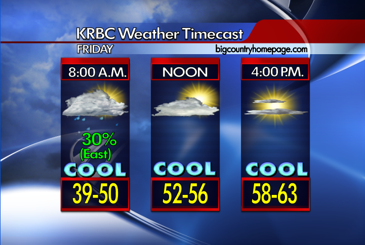

Good Morning from KRBC Meteorologist Chris Whited...
* Showers continue across the eastern and southeastern areas this morning and should be confined to this area the rest of the morning. I think for the rest of us, we'll be mostly cloudy with clouds gradually breaking up heading into the day. Temperatures cooler today with highs in the upper 50s and lower 60s. A few clouds still around tonight with cool temperatures into the upper 30s.
* Weekend: Forecast looks good for the weekend for the area. Sky conditions will be mostly sunny with highs on Saturday in the upper 60s and Sunday into the lower 70s. Overnight lows will be in the upper 30s on Saturday morning but the upper 40s on Sunday morning.
* Next Week: One front will arrive on late Monday bringing in cooler weather for next week but a stronger front should arrive by the middle of next week. Models have backed off with the front the middle of next week. Highs in the 70s Monday but upper 50s/low 60s next week. Thanksgiving Day looks to be nice, although a bit cool.
* Winter Outlook: The Climate Prediction Center indicates a moderate El Niño pattern is taking shape and will bring West Central Texas a wetter pattern for the winter months. There is also a chance for increased winter precipitation depending on temperature trends. Data suggests equal chances of above or below normal temperatures, so more than likely the numbers will remain near normal for this time of year.
* Drought Information: For the lastest drought information for the state of Texas please visit the U.S Drought Monitor website by clicking here. The data is updated by the government every Thursday morning around 7:30 AM.
* Tropics: For the latest information please visit the KRBC/NBC Hurricane Season 2009 Tracker on the weather section of our website by clicking here. You can also visit the National Hurricane Center website by clicking on the link here. The 2009 Atlantic hurricane season will end on November 30th.
* Join us on television this morning for the latest on your forecast as well as news from around Abilene & the Big Country on KRBC's Abilene Today starting at 6:00 AM and on Abilene Midday later this morning at 11:30 AM. More news and weather coverage continues this afternoon at 5:00 and tonight 6:00 and 10:00 PM on KRBC.
* Twitter: You can follow us on twitter anytime for quick weather updates, especially during severe weather events affecting the Big Country by visiting the KRBC Weather Twitter. You can also check out news updates from KRBC via twitter also by visiting the Big Country Homepage Twitter.
Enjoy your weekend...
Thursday, November 19, 2009
Clouds Return Today, Rain Returns Tonight:

 Good Morning from KRBC Meteorologist Chris Whited...
* Unlike the last couple of mornings, we're all waking up to much warmer temperatures this morning. It's a bit breezy out there and expect the breeze to stay with us today. Clouds will slowly return as we get into the day with our highs today in the middle 70s. Expect conditions to be mostly cloudy to cloudy tonight. A cold front still on track to move through overnight. Showers and a few thunderstorms will be possible. Lows tonight in the the middle 40s. The rain should be out of here by early in the morning. Clouds will decrease on Friday but it will be cooler with highs in the lower 60s.
* Weekend: Forecast looks good for the weekend for the area. Sky conditions will be mostly sunny with highs on Saturday and Sunday into the upper 60s. Overnight lows will be in the upper 30s on Saturday morning but the upper 40s on Sunday morning.
* Next Week: One front will arrive on Monday bringing a bit of cooler weather for next week but a stronger front should arrive by the middle of next week. Models are showing some rain chance for the area on Wednesday so I decided to go ahead and mention the chance in my morning forecast package. Highs in the 70s Monday but upper 50s/low 60s next week. Could see a freeze again by the middle of next weeek.
* Winter Outlook: The Climate Prediction Center indicates a moderate El Niño pattern is taking shape and will bring West Central Texas a wetter pattern for the winter months. There is also a chance for increased winter precipitation depending on temperature trends. Data suggests equal chances of above or below normal temperatures, so more than likely the numbers will remain near normal for this time of year.
* Drought Information: For the lastest drought information for the state of Texas please visit the U.S Drought Monitor website by clicking here. The data is updated by the government every Thursday morning around 7:30 AM.
* Tropics: For the latest information please visit the KRBC/NBC Hurricane Season 2009 Tracker on the weather section of our website by clicking here. You can also visit the National Hurricane Center website by clicking on the link here. The 2009 Atlantic hurricane season will end on November 30th.
* Join us on television this morning for the latest on your forecast as well as news from around Abilene & the Big Country on KRBC's Abilene Today starting at 6:00 AM and on Abilene Midday later this morning at 11:30 AM. More news and weather coverage continues this afternoon at 5:00 and tonight 6:00 and 10:00 PM on KRBC.
* Twitter: You can follow us on twitter anytime for quick weather updates, especially during severe weather events affecting the Big Country by visiting the KRBC Weather Twitter. You can also check out news updates from KRBC via twitter also by visiting the Big Country Homepage Twitter.
Have a Nice Thursday...
* Drought Information: For the lastest drought information for the state of Texas please visit the U.S Drought Monitor website by clicking here. The data is updated by the government every Thursday morning around 7:30 AM.
* Tropics: For the latest information please visit the KRBC/NBC Hurricane Season 2009 Tracker on the weather section of our website by clicking here. You can also visit the National Hurricane Center website by clicking on the link here. The 2009 Atlantic hurricane season will end on November 30th.
* Join us on television this morning for the latest on your forecast as well as news from around Abilene & the Big Country on KRBC's Abilene Today starting at 6:00 AM and on Abilene Midday later this morning at 11:30 AM. More news and weather coverage continues this afternoon at 5:00 and tonight 6:00 and 10:00 PM on KRBC.
* Twitter: You can follow us on twitter anytime for quick weather updates, especially during severe weather events affecting the Big Country by visiting the KRBC Weather Twitter. You can also check out news updates from KRBC via twitter also by visiting the Big Country Homepage Twitter.
Have a Nice Thursday...
Wednesday, November 18, 2009
Another Cold Start, Warm This Afternoon:

 Good Morning from KRBC Meteorologist Chris Whited...
*** The National Weather Service in San Angelo has issued a Freeze Warning for Taylor, Coleman, Brown, Haskell, Callahan, Throckmorton, Shackelford and Jones County until 9:00 AM. ***
*** The National Weather Service in Fort Worth has issued a Freeze Warning for Stephens, Eastland and Comanche County until 9:00 AM. ***
*** The National Weather Service in Lubbock has issued a Freeze Warning for Stonewall, Kent and King County until 9:00 AM.***
*** The National Weather Service in Norman has issued a Freeze Warning for Knox County until 8:00 AM. ***
* Another cold start this morning with some areas at or just below freezing. A nice day ahead with temperatures warming up to near 70 this afternoon. Not as cold tonight thanks to a south wind, our temperatures will drop into the middle 40s. Partly cloudy on Thursday with highs in the lower to middle 70s. A cold front arrives late Thursday bringing a slight rain chance for late Thursday and early Friday. The best rain chances should be south and east of Interstate 20.
* Weekend: Expect mostly sunny conditions over the weekend with daytime highs in the middle to upper 60s. Overnight lows will be in the upper 30s on Saturday morning and we'll be into the middle 40s Sunday morning.
* Next Week: Another cold front will arrive on Monday. Models bring this front in with a dry airmass so no rain chances expected for the Big Country. We will see some more clouds with the front. Temperatures in the 60s behind the front and lows getting back into the lower 40s and upper 30s.
* Winter Outlook: The Climate Prediction Center indicates a moderate El Niño pattern is taking shape and will bring West Central Texas a wetter pattern for the winter months. There is also a chance for increased winter precipitation depending on temperature trends. Data suggests equal chances of above or below normal temperatures, so more than likely the numbers will remain near normal for this time of year.
* Drought Information: For the lastest drought information for the state of Texas please visit the U.S Drought Monitor website by clicking here. The data is updated by the government every Thursday morning around 7:30 AM.
* Tropics: For the latest information please visit the KRBC/NBC Hurricane Season 2009 Tracker on the weather section of our website by clicking here. You can also visit the National Hurricane Center website by clicking on the link here. The 2009 Atlantic hurricane season will end on November 30th.
* Join us on television this morning for the latest on your forecast as well as news from around Abilene & the Big Country on KRBC's Abilene Today starting at 6:00 AM and on Abilene Midday later this morning at 11:30 AM. More news and weather coverage continues this afternoon at 5:00 and tonight 6:00 and 10:00 PM on KRBC.
* Twitter: You can follow us on twitter anytime for quick weather updates, especially during severe weather events affecting the Big Country by visiting the KRBC Weather Twitter. You can also check out news updates from KRBC via twitter also by visiting the Big Country Homepage Twitter.
Enjoy your Wednesday...
Tuesday, November 17, 2009
Freeze Warning For Overnight & Wednesday Morning:


From the KRBC Weather Lab:
* The National Weather Service in San Angelo has issued a Freeze Warning for Taylor, Coleman, Brown, Haskell, Callahan, Throckmorton, Shackelford and Jones County for overnight and into the morning hours on Wednesday until 9:00 AM
* The National Weather Service in Fort Worth has issued a Freeze Warning for Stephens, Eastland and Comanche County for overnight and into the morning hours on Wednesday until 9:00 AM
* The National Weather Service in Lubbock has issued a Freeze Warning for Stonewall, Kent and King County for overnight and into the morning hours on Wednesday until 9:00 AM.
* The National Weather Service in Norman has issued a Freeze Warning for Knox County for overnight and into the morning hours on Wednesday until 8:00 AM.
* A Freeze Warning is issued during the growing season when surface temperatures are expected to drop below freezing over a large area for an extended period of time, regardless whether or not frost develops. A Freeze Watch is issued when sub-freezing temperatures are possible. These conditions could kill crops and other sensitive vegetation
Cold Start But Mild This Afternoon:

Good Morning from Meteorologist Chris Whited...
*** Freeze Warning in effect for Taylor, Nolan, Callahan, Eastland, Shackelford, Stephens, Jones, Fisher, Mitchell, Scurry, Haskell, Stonewall, Throckmorton, Knox, Coke, Runnels, Coleman, Brown, and Comanche County until 9:00 AM this morning ***
* A very cold start this morning but a nice day ahead with temperatures warming up into the middle 60s this afternoon. Another cold night ahead with lows in the lower 30s, so expect a freeze again for most of us. Temperatures much warmer tomorrow with highs in the lower 70s. The first of two cold fronts arrives late Thursday/early Friday. Looks like most of the moisture will be off to the east. Another front is due into the area come Monday, also looks to be that all the moisture will set up east of the area. Temperatures ease back into the 60s late week and into the weekend and overnight lows drop back into the upper 30s and lower/middle 40s.
* Winter Outlook: The Climate Prediction Center indicates a moderate El Niño pattern is taking shape and will bring West Central Texas a wetter pattern for the winter months. There is also a chance for increased winter precipitation depending on temperature trends. Data suggests equal chances of above or below normal temperatures, so more than likely the numbers will remain near normal for this time of year.
* Drought Information: For the lastest drought information for the state of Texas please visit the U.S Drought Monitor website by clicking here. The data is updated by the government every Thursday morning around 7:30 AM.
* Tropics: For the latest information please visit the KRBC/NBC Hurricane Season 2009 Tracker on the weather section of our website by clicking here. You can also visit the National Hurricane Center website by clicking on the link here. The 2009 Atlantic hurricane season will end on November 30th.
* Join us on television this morning for the latest on your forecast as well as news from around Abilene & the Big Country on KRBC's Abilene Today starting at 6:00 AM and on Abilene Midday later this morning at 11:30 AM. More news and weather coverage continues this afternoon at 5:00 and tonight 6:00 and 10:00 PM on KRBC.
* Twitter: You can follow us on twitter anytime for quick weather updates, especially during severe weather events affecting the Big Country by visiting the KRBC Weather Twitter. You can also check out news updates from KRBC via twitter also by visiting the Big Country Homepage Twitter.
Enjoy your Tuesday...
Monday, November 16, 2009
Freeze Warning In Effect Tonight/Tuesday Morning:
From the KRBC Weather Lab:
* The National Weather Service in San Angelo has issued a Freeze Warning for Taylor, Coleman, Brown, Fisher, Nolan, Haskell, Coke, Runnels, Callahan, Throckmorton, Shackelford and Jones County for Monday night and into the morning hours on Tuesday.
* The National Weather Service in Fort Worth has issued a Freeze Warning for Stephens, Eastland and Comanche County for Monday night and into the morning hours on Tuesday.
* The National Weather Service in Midland has issued a Freeze Warning for Mitchell & Scurry County for Monday night and into the morning hours on Tuesday morning.
* The National Weather Service in Lubbock has issued a Freeze Watch for Stonewall County for Monday night and into the morning hours on Tuesday.
* The National Weather Service in Norman has issued a Freeze Watch for Knox County for Monday night and into the morning hours on Tuesday.
* A Freeze Warning is issued during the growing season when surface temperatures are expected to drop below freezing over a large area for an extended period of time, regardless whether or not frost develops. A Freeze Watch is issued when sub-freezing temperatures are possible. These conditions could kill crops and other sensitive vegetation
First Fall Freeze Ahead Tonight:

 Good Morning from Meteorologist Chris Whited...
*** Freeze Warning in effect for Mitchell & Scurry County for overnight and into early Tuesday. Freeze Watch in effect for Taylor, Coleman, Brown, Fisher, Nolan, Haskell, Coke, Runnels, Jones, Stonewall & Knox County for overnight and into Tuesday morning ***
*** Wind Advisory in effect for Eastland, Stephens and Comanche County into the afternoon hours ***
* Cold front has made it through West Central Texas this morning. A few low clouds are hanging behind the front but will quickly burn off as we get into the day. Cooling down out there with a breezy northwest wind behind the front filtering the cooler air into the area. Winds should vary between 15-25 mph, with a higher gust at times. Expect a mostly sunny day and much cooler with highs mostly in the upper 50s, though a few spots down near the Colorado River might make it into the lower 60s. The winds will begin to let up as we head into the afternoon. A very cold night ahead and for many of us this will be the first freeze of the season. Freeze Watch in effect for most areas, while a Freeze Warning is effect for the western areas, including Snyder and Colorado City. Lows tonight in the lower 30s and I wouldn't be surprised if a few spots dipped into the upper 20s.
* Temperatures will be more seasonal but warming up some as we head into the week with highs in the upper 60s to low 70s with overnight lows eventually settling back into the 40s. Sunny conditions will prevail most of the week ahead with some clouds returning late week and into the weekend. Models hint at a slight rain chance come Sunday but I've decided not to include it in my forecast package this morning. I'd like to wait and see some more data before adding in the rain chance.
* Winter Outlook: The Climate Prediction Center indicates a moderate El Niño pattern is taking shape and will bring West Central Texas a wetter pattern for the winter months. There is also a chance for increased winter precipitation depending on temperature trends. Data suggests equal chances of above or below normal temperatures, so more than likely the numbers will remain near normal for this time of year.
* Drought Information: For the lastest drought information for the state of Texas please visit the U.S Drought Monitor website by clicking here. The data is updated by the government every Thursday morning around 7:30 AM.
* Tropics: For the latest information please visit the KRBC/NBC Hurricane Season 2009 Tracker on the weather section of our website by clicking here. You can also visit the National Hurricane Center website by clicking on the link here. The 2009 Atlantic hurricane season will end on November 30th.
* Join us on television this morning for the latest on your forecast as well as news from around Abilene & the Big Country on KRBC's Abilene Today starting at 6:00 AM and on Abilene Midday later this morning at 11:30 AM. More news and weather coverage continues this afternoon at 5:00 and tonight 6:00 and 10:00 PM on KRBC.
* Twitter: You can follow us on twitter anytime for quick weather updates, especially during severe weather events affecting the Big Country by visiting the KRBC Weather Twitter. You can also check out news updates from KRBC via twitter also by visiting the Big Country Homepage Twitter.
Enjoy your Monday...
Friday, November 13, 2009
Changes Ahead In The Weather Pattern:

 Good Morning from KRBC Meteorologist Chris Whited...
* Expect a partly cloudy day with afternoon highs topping out near 80. Partly cloudy conditions will remain in place tonight with lows in the midle to upper 50s. Breezy conditions will prevail through the weekend. Weather not to bad for high school football games across the region tonight.
* Weekend: Remaining partly cloudy on Saturday with highs in the upper 70s/lower 80s and overnight lows in the middle 50s. Clouds will increase for the day on Sunday. The cold front still on track to move in area early on Sunday increasing chances for a few showes and maybe an isolated thunderstorms. The rain should end by Monday morning.
* Next Week: Cooler air arriving with the front on Sunday. Expect highs in the 50s for Monday and Tuesday and 60s into the middle of next week. Cold nights return with lows in the 30s through the middle of next week. The forecast looks dry into next week.
* Winter Outlook: The Climate Prediction Center indicates a moderate El Niño pattern is taking shape and will bring West Central Texas a wetter pattern for the winter months. There is also a chance for increased winter precipitation depending on temperature trends. Data suggests equal chances of above or below normal temperatures, so more than likely the numbers will remain near normal for this time of year.
* First Freeze Dates: We're pretty much right on the time frame for the average first freeze dates for the fall season for us here in our part of West Central Texas.Here are just a few of the dates as reported by the San Angelo National Weather Service: Abilene - November 12, Coleman - November 13, Brownwood - November 13, Ballinger - November 9, and Rotan - November 12. The National Weather Service has indicated that some areas could run a little late getting to the first freeze for this year. So far the coldest we've seen this fall for Abilene has been has been 34 back on October 27.
* Drought Information: For the lastest drought information for the state of Texas please visit the U.S Drought Monitor website by clicking here. The data is updated by the government every Thursday morning around 7:30 AM.
* Tropics: For the latest information please visit the KRBC/NBC Hurricane Season 2009 Tracker on the weather section of our website by clicking here. You can also visit the National Hurricane Center website by clicking on the link here. The 2009 Atlantic hurricane season will end on November 30th.
* Join us on television this morning for the latest on your forecast as well as news from around Abilene & the Big Country on KRBC's Abilene Today starting at 6:00 AM and on Abilene Midday later this morning at 11:30 AM. More news and weather coverage continues this afternoon at 5:00 and tonight 6:00 and 10:00 PM on KRBC.
* Twitter: You can follow us on twitter anytime for quick weather updates, especially during severe weather events affecting the Big Country by visiting the KRBC Weather Twitter. You can also check out news updates from KRBC via twitter also by visiting the Big Country Homepage Twitter.
Enjoy your weekend...
Thursday, November 12, 2009
Dense Fog This Morning, Nice Afternoon


*** Dense Fog Advisory in effect for the areas north of Interstate 20 here in the Big Country until 9:00 AM ***
Good Morning from KRBC Meteorologist Chris Whited...
* Dense areas of patchy fog have developed again this morning across the Big Country. Dense Fog Advisory has been issued through mid-morning so give yourself a little extra time headling out. The fog will disspate by late morning with a nice day ahead. Expect a partly cloudy day with afternoon highs topping out in the upper 70s. Partly cloudy conditions will remain in place tonight with lows in the middle 50s. Winds will pick up today so expect breezy periods at times.
* Remaining partly cloudy through Saturday with highs in the upper 70s/lower 80s and overnight lows in the middle 50s. The cold front still on track to move in area early on Sunday increasing chances for showes and a few thunderstorms. No severe weather is expected at this time. The rain should end by Monday morning. Cooler air arriving with the front. Highs in the upper 60s Sunday, 50s on Monday and back into the 60s by Tuesday and Wednesday. Overnight lows drop into the 40s Monday night and we're into the 30s by the middle of the week.
* Winter Outlook: The Climate Prediction Center indicates a moderate El Niño pattern is taking shape and will bring West Central Texas a wetter pattern for the winter months. There is also a chance for increased winter precipitation depending on temperature trends. Data suggests equal chances of above or below normal temperatures, so more than likely the numbers will remain near normal for this time of year.
* First Freeze Dates: We're pretty much right on the time frame for the average first freeze dates for the fall season for us here in our part of West Central Texas.Here are just a few of the dates as reported by the San Angelo National Weather Service: Abilene - November 12, Coleman - November 13, Brownwood - November 13, Ballinger - November 9, and Rotan - November 12. The National Weather Service has indicated that some areas could run a little late getting to the first freeze for this year. So far the coldest we've seen this fall for Abilene has been has been 34 back on October 27.
* Drought Information: For the lastest drought information for the state of Texas please visit the U.S Drought Monitor website by clicking here. The data is updated by the government every Thursday morning around 7:30 AM.
* Tropics: For the latest information please visit the KRBC/NBC Hurricane Season 2009 Tracker on the weather section of our website by clicking here. You can also visit the National Hurricane Center website by clicking on the link here. The 2009 Atlantic hurricane season will end on November 30th.
* Join us on television this morning for the latest on your forecast as well as news from around Abilene & the Big Country on KRBC's Abilene Today starting at 6:00 AM and on Abilene Midday later this morning at 11:30 AM. More news and weather coverage continues this afternoon at 5:00 and tonight 6:00 and 10:00 PM on KRBC.
* Twitter: You can follow us on twitter anytime for quick weather updates, especially during severe weather events affecting the Big Country by visiting the KRBC Weather Twitter. You can also check out news updates from KRBC via twitter also by visiting the Big Country Homepage Twitter.
Enjoy your Thursday...
Wednesday, November 11, 2009
A Pleasant Veterans Day Forecast:

 Good Morning from KRBC Meteorologist Chris Whited...
* Once again here in the morning some areas of patchy fog in spots across the Big Country, Heartland and Northern Concho Valley so give yourself a little extra time headling out. Would not be surprised if we get placed under another Dense Fog Advisory like we saw yesterday moring. The fog will disspate by late morning with a nice day ahead. Expect a mostly sunny day with afternoon highs topping out in the middle 70s. A few clouds are possible tonight with lows again in the low 50s, with a few upper 40s.
* Expect partly cloudy days through Saturday with highs in the middle and upper 70s and overnight lows in the lower to middle 50s. The cold front still on track to move in area early on Sunday increasing chances for showes and a few thunderstorms. No severe weather is expected at this time. The rain should end by Monday morning. Cooler air arriving with the front. Highs in the 60s Sunday, 50s on Monday and back into the 60s by Tuesday. Overnight lows should be in the upper 30s and lower 40s behind the front.
* Winter Outlook: The Climate Prediction Center indicates a moderate El Niño pattern is taking shape and will bring West Central Texas a wetter pattern for the winter months. There is also a chance for increased winter precipitation depending on temperature trends. Data suggests equal chances of above or below normal temperatures, so more than likely the numbers will remain near normal for this time of year.
* First Freeze Dates: We're pretty much right on the time fram for the average first freeze dates for the fall season for us here in our part of West Central Texas.Here are just a few of the dates as reported by the San Angelo National Weather Service: Abilene - November 12, Coleman - November 13, Brownwood - November 13, Ballinger - November 9, and Rotan - November 12. The National Weather Service has indicated that some areas could run a little late getting to the first freeze for this year. So far the coldest we've seen this fall for Abilene has been has been 34 back on October 27.
* Drought Information: For the lastest drought information for the state of Texas please visit the U.S Drought Monitor website by clicking here. The data is updated by the government every Thursday morning around 7:30 AM.
* Tropics: For the latest information please visit the KRBC/NBC Hurricane Season 2009 Tracker on the weather section of our website by clicking here. You can also visit the National Hurricane Center website by clicking on the link here. The 2009 Atlantic hurricane season will end on November 30th.
* Join us on television this morning for the latest on your forecast as well as news from around Abilene & the Big Country on KRBC's Abilene Today starting at 6:00 AM and on Abilene Midday later this morning at 11:30 AM. More news and weather coverage continues this afternoon at 5:00 and tonight 6:00 and 10:00 PM on KRBC.
* Twitter: You can follow us on twitter anytime for quick weather updates, especially during severe weather evenings affecting the Big Country by visiting the KRBC Weather Twitter. You can also check out news updates from KRBC via twitter also by visiting the Big Country Homepage Twitter.
Have a wonderful Veterans Day on this Wednesday...
Tuesday, November 10, 2009
Nice November Day Ahead:

 Good Morning from KRBC Meteorologist Chris Whited...
* Patchy fog in spots across the Big Country, Heartland and Northern Concho Valley this morning so give yourself a little extra time headling out. Fog will disspate by late morning with a nice day ahead. Expect a partly cloudy sky with temperatures in mostly in the middle 70s. A few clouds still possible tonight and looks like fog will redevelop overnight again with lows in the upper 40s and lower 50s.
* The rest of the week still looks pretty quiet with mostly sunny to partly cloudy days with highs in the middle and upper 70s and overnight lows in the lower to middle 50s. A cold front still on track to move in late Saturday and early on Sunday and bring us a slight chance for rain and some cooler temperatures with highs dropping back into the 60s.
* November Outlook: The Climate Prediction Center is forecasting a wetter month for West Central Texas due to the return of El Niño and its effects on Texas. As far as temperatures go, the data suggests equal chances of above or below normal temperatures, so more than likely the numbers will remain near normal for this time of year.
* First Freeze Dates: The average first freeze of the fall season for us here in our part of West Central Texas is in the early to middle part of November. Here are just a few of the dates as reported by the San Angelo National Weather Service: Abilene - November 12, Coleman - November 13, Brownwood - November 13, Ballinger - November 9, and Rotan - November 12.
* Drought Information: For the lastest drought information for the state of Texas please visit the U.S Drought Monitor website by clicking here. The data is updated by the government every Thursday morning around 7:30 AM.
* Tropics: For the latest information please visit the KRBC/NBC Hurricane Season 2009 Tracker on the weather section of our website by clicking here. You can also visit the National Hurricane Center website by clicking on the link here. The 2009 Atlantic hurricane season will end on November 30th.
* Join us on television this morning for the latest on your forecast as well as news from around Abilene & the Big Country on KRBC's Abilene Today starting at 6:00 AM and on Abilene Midday later this morning at 11:30 AM. More news and weather coverage continues this afternoon at 5:00 and tonight 6:00 and 10:00 PM on KRBC.
* Twitter: You can follow us on twitter anytime for quick weather updates, especially during severe weather evenings affecting the Big Country by visiting the KRBC Weather Twitter. You can also check out news updates from KRBC via twitter also by visiting the Big Country Homepage Twitter.
Enjoy your Tuesday...
Monday, November 09, 2009
Weather Looks Dry This Week
From KRBC Chief Meteorologist Randy Turner ....
The weather will be rather uneventful this week in the Big Country.
We have a cold front coming in tonight (Monday) which should keep some clouds lingering around the area Tuesday. I'm forecasting a high of 68 on Tuesday with a light northeast wind 5 to 10.
The rest of the week we will see highs in the low to mid 70's during the day and the low 50's at night.
The next front is due Saturday night and that brings just a slight chance for showers and cooler weather for Sunday.
The weather will be rather uneventful this week in the Big Country.
We have a cold front coming in tonight (Monday) which should keep some clouds lingering around the area Tuesday. I'm forecasting a high of 68 on Tuesday with a light northeast wind 5 to 10.
The rest of the week we will see highs in the low to mid 70's during the day and the low 50's at night.
The next front is due Saturday night and that brings just a slight chance for showers and cooler weather for Sunday.
AM Clouds & PM Sunshine Today:

 Good Morning from KRBC Meteorologist Chris Whited...
* Morning clouds and fog across the area this morning will give way towards midday as sky conditions become partly cloudy. A rather warm day with highs in the middle 70s. Partly cloudy for tonight with lows near 50° in most areas, a few spots in the upper 40s. A weak cold front will move through this afternoon.
* This Week: Rather quiet week with an upper level ridge settling in over Texas. This will keep us mostly sunny to partly cloudy. Temperatures will be above normal for November with middle 70s for highs and lows in the middle 50s. Another cold front is due on Saturday that will bring some cooler weather. There is slight chance of rain Saturday night and Sunday with the front.
* Next Week: Our nice weather trend will sorta come to a brief end as the pattern chance will bring a decent cold front into the area on Monday. We'll include a slight chance for showers or an isolated storm Monday afternoon, Monday night and early on Tuesday. Cooler air will arrive with the front as temperatures will drop back into the 60s for highs next week and lows into the 40s.
* November Outlook: The Climate Prediction Center is forecasting a wetter month for West Central Texas due to the return of El Niño and its effects on Texas. As far as temperatures go, the data suggests equal chances of above or below normal temperatures, so more than likely the numbers will remain near normal for this time of year.
* First Freeze Dates: The average first freeze of the fall season for us here in our part of West Central Texas is in the early to middle part of November. Here are just a few of the dates as reported by the San Angelo National Weather Service: Abilene - November 12, Coleman - November 13, Brownwood - November 13, Ballinger - November 9, and Rotan - November 12.
* Drought Information: For the lastest drought information for the state of Texas please visit the U.S Drought Monitor website by clicking here. The data is updated by the government every Thursday morning around 7:30 AM.
* Tropics: For the latest information please visit the KRBC/NBC Hurricane Season 2009 Tracker on the weather section of our website by clicking here. You can also visit the National Hurricane Center website by clicking on the link here. The 2009 Atlantic hurricane season will end on November 30th.
* Join us on television this morning for the latest on your forecast as well as news from around Abilene & the Big Country on KRBC's Abilene Today starting at 6:00 AM and on Abilene Midday later this morning at 11:30 AM. More news and weather coverage continues this afternoon at 5:00 and tonight 6:00 and 10:00 PM on KRBC.
* Twitter: You can follow us on twitter anytime for quick weather updates, especially during severe weather evenings affecting the Big Country by visiting the KRBC Weather Twitter. You can also check out news updates from KRBC via twitter also by visiting the Big Country Homepage Twitter.
Have a great Monday...
Sunday, November 08, 2009
Few Showers Possible
From KRBC Chief Meteorologist Randy Turner ....
I'm leaving a slight chance for showers in the forecast Sunday night and Monday, but have little confidence that we'll see much in the way of rain.
The overall pattern this week leans to dry weather as major weather systems continue to stay away.
Hurricane Ida is a big story, but will affect Florida, the Deep South and Gulf Coast.
The storm track for northern systems also stays north and away from us, leaving mild temperatures.
A couple of cold fronts will pass through on Monday night, then again this coming weekend, but both look like minor fronts.
Temperatures will stay a few degrees above 70 most of the week with lows near 50.
I'm leaving a slight chance for showers in the forecast Sunday night and Monday, but have little confidence that we'll see much in the way of rain.
The overall pattern this week leans to dry weather as major weather systems continue to stay away.
Hurricane Ida is a big story, but will affect Florida, the Deep South and Gulf Coast.
The storm track for northern systems also stays north and away from us, leaving mild temperatures.
A couple of cold fronts will pass through on Monday night, then again this coming weekend, but both look like minor fronts.
Temperatures will stay a few degrees above 70 most of the week with lows near 50.
Friday, November 06, 2009
Nice Weekend Weather / Rain Possible Early Week
From Randy Turner ....
Nice weather this weekend, dry. Sunny and about 80 Saturday. More clouds Sunday with highs closer to 70.
A bit windy from the south 10 to 20 this weekend.
A cold front approaches late Monday. It may mean a few showers Monday night into Tuesday morning, but I'm not expecting significant amounts.
Temperatures Monday around 66, around 63 Tuesday.
Dry weather Wednesday through Friday of next week but as we get to middle month, rain likely to return.
Have a great weekend !!!
Nice weather this weekend, dry. Sunny and about 80 Saturday. More clouds Sunday with highs closer to 70.
A bit windy from the south 10 to 20 this weekend.
A cold front approaches late Monday. It may mean a few showers Monday night into Tuesday morning, but I'm not expecting significant amounts.
Temperatures Monday around 66, around 63 Tuesday.
Dry weather Wednesday through Friday of next week but as we get to middle month, rain likely to return.
Have a great weekend !!!
Nice End To Week, Changes Next Week:


Good Morning from KRBC Meteorologist Chris Whited...
* Another nice weather day is in store for Big Country, Heartland and Northern Concho Valley with plenty of blue sky and sunshine.Temperatures will be warmer with highs near 80 in most spots. Mostly clear tonight but a couple of high clouds could roll in late. Not as cool tonight with lows in the middle 50s.
* Weekend: Mostly sunny on Saturday but expect more clouds in the area on Sunday ahead of a disturbance and a cold front arriving by Monday. Highs on Saturday will range in the middle to upper 70s. Sunday high temperatures will average in the middle 70s. Lows in the middle 50s. No rain chances expected for the weekend.
* Next Week: Our nice weather trend will sorta come to a brief end as the pattern chance will bring a decent cold front into the area on Monday. We'll include a slight chance for showers or an isolated storm Monday afternoon, Monday night and early on Tuesday. Cooler air will arrive with the front as temperatures will drop back into the 60s for highs next week and lows into the 40s.
* November Outlook: The Climate Prediction Center is forecasting a wetter month for West Central Texas due to the return of El Niño and its effects on Texas. As far as temperatures go, the data suggests equal chances of above or below normal temperatures, so more than likely the numbers will remain near normal for this time of year.
* First Freeze Dates: The average first freeze of the fall season for us here in our part of West Central Texas is in the early to middle part of November. Here are just a few of the dates as reported by the San Angelo National Weather Service: Abilene - November 12, Coleman - November 13, Brownwood - November 13, Ballinger - November 9, and Rotan - November 12.
* Drought Information: For the lastest drought information for the state of Texas please visit the U.S Drought Monitor website by clicking here. The data is updated by the government every Thursday morning around 7:30 AM.
* Tropics: For the latest information please visit the KRBC/NBC Hurricane Season 2009 Tracker on the weather section of our website by clicking here. You can also visit the National Hurricane Center website by clicking on the link here. The 2009 Atlantic hurricane season will end on November 30th.
* Join us on television this morning for the latest on your forecast as well as news from around Abilene & the Big Country on KRBC's Abilene Today starting at 6:00 AM and on Abilene Midday later this morning at 11:30 AM. More news and weather coverage continues this afternoon at 5:00 and tonight 6:00 and 10:00 PM on KRBC.
* Twitter: You can follow us on twitter anytime for quick weather updates, especially during severe weather evenings affecting the Big Country by visiting the KRBC Weather Twitter. You can also check out news updates from KRBC via twitter also by visiting the Big Country Homepage Twitter.
Have a great weekend...
Thursday, November 05, 2009
Another Nice Fall Weather Day:


Good Morning from KRBC Meteorologist Chris Whited...
* Another nice day ahead for the Big Country, Heartland and Northern Concho Valley with plenty of blue sky and sunshine. Temperatures will be warmer with highs in the upper 70s. Mainly clear tonight but a couple of high clouds could roll in late. Not as cool tonight with lows in the lower 50s. Nice weather for Friday and Saturday with mostly sunny conditions and highs in the upper 70s and a few spots at 80° but clouds will return on Sunday. Next cold front is due in on Monday so will continue to include a slight chance for showers or an isolated storm Monday, Monday night and early on Tuesday. Cooler air will arrive with the front as temperatures will drop back into the 60s for highs next week.
* November Outlook: The Climate Prediction Center is forecasting a wetter month for West Central Texas due to the return of El Niño and its effects on Texas. As far as temperatures go, the data suggests equal chances of above or below normal temperatures, so more than likely the numbers will remain near normal for this time of year.
* First Freeze Dates: The average first freeze of the fall season for us here in our part of West Central Texas is in the early to middle part of November. Here are just a few of the dates as reported by the San Angelo National Weather Service: Abilene - November 12, Coleman - November 13, Brownwood - November 13, Ballinger - November 9, and Rotan - November 12.
* Drought Information: For the lastest drought information for the state of Texas please visit the U.S Drought Monitor website by clicking here. The data is updated by the government every Thursday morning around 7:30 AM.
* Tropics: For the latest information please visit the KRBC/NBC Hurricane Season 2009 Tracker on the weather section of our website by clicking here. You can also visit the National Hurricane Center website by clicking on the link here. The 2009 Atlantic hurricane season will end on November 30th.
* Join us on television this morning for the latest on your forecast as well as news from around Abilene & the Big Country on KRBC's Abilene Today starting at 6:00 AM and on Abilene Midday later this morning at 11:30 AM. More news and weather coverage continues this afternoon at 5:00 and tonight 6:00 and 10:00 PM on KRBC.
* Twitter: You can follow us on twitter anytime for quick weather updates, especially during severe weather evenings affecting the Big Country by visiting the KRBC Weather Twitter. You can also check out news updates from KRBC via twitter also by visiting the Big Country Homepage Twitter.
Have a great Thursday...
Wednesday, November 04, 2009
Another Nice Day Ahead:


Good Morning from KRBC Meteorologist Chris Whited...
* Same old song and dance in the weather department but we can't complain about the selection! Pleasant weather continues for us with abundant sunshine today with high temperatures in the middle 70s. Clear and cool tonight with lows in the upper 40s. Another sunny day ahead for Thursday with temperatures a tad warmer in the middle and upper 70s. Some clouds will return heading into the weekend but no rain with these clouds. Models continue to bring a front into the Big Country on Monday that will increase clouds and bring some rain chances. Also looks like some cooler air will arrive behind this front.
* November Outlook: The Climate Prediction Center is forecasting a wetter month for West Central Texas due to the return of El Niño and its effects on Texas. As far as temperatures go, the data suggests equal chances of above or below normal temperatures, so more than likely the numbers will remain near normal for this time of year.
* First Freeze Dates: The average first freeze of the fall season for us here in our part of West Central Texas is in the early to middle part of November. Here are just a few of the dates as reported by the San Angelo National Weather Service: Abilene - November 12, Coleman - November 13, Brownwood - November 13, Ballinger - November 9, and Rotan - November 12.
* Drought Information: For the lastest drought information for the state of Texas please visit the U.S Drought Monitor website by clicking here. The data is updated by the government every Thursday morning around 7:30 AM.
* Tropics: For the latest information please visit the KRBC/NBC Hurricane Season 2009 Tracker on the weather section of our website by clicking here. You can also visit the National Hurricane Center website by clicking on the link here. The 2009 Atlantic hurricane season will end on November 30th.
* Join us on television this morning for the latest on your forecast as well as news from around Abilene & the Big Country on KRBC's Abilene Today starting at 6:00 AM and on Abilene Midday later this morning at 11:30 AM. More news and weather coverage continues this afternoon at 5:00 and tonight 6:00 and 10:00 PM on KRBC.
* Twitter: You can follow us on twitter anytime for quick weather updates, especially during severe weather evenings affecting the Big Country by visiting the KRBC Weather Twitter. You can also check out news updates from KRBC via twitter also by visiting the Big Country Homepage Twitter.
Enjoy your Wednesday...
Tuesday, November 03, 2009
Pleasant Weather Remains In Place:


Good Morning from KRBC Meteorologist Chris Whited...
* Quiet weather pattern remains in place for West Central Texas. A weak front is washing out across the region but didn't really bring much of an effect other than a wind shift. Abundant sunshine in store for today with highs in the upper 60s and lower 70s. Clear tonight and a few degrees warmer with lows in the upper 40s and lower 50s. A few high clouds will roll into the area by late week but the pattern will remain quiet. Models develop a trough across the western part of the country that could bring us a slight rain chance early next week but my confidence is pretty low right now so I am not going to insert rain yet into the forecast by the end of the seven day forecast period.
* November Outlook: The Climate Prediction Center is forecasting a wetter month for West Central Texas due to the return of El Niño and its effects on Texas. As far as temperatures go, the data suggests equal chances of above or below normal temperatures, so more than likely the numbers will remain near normal for this time of year.
* First Freeze Dates: The average first freeze of the fall season for us here in our part of West Central Texas is in the early to middle part of November. Here are just a few of the dates as reported by the San Angelo National Weather Service: Abilene - November 12, Coleman - November 13, Brownwood - November 13, Ballinger - November 9, and Rotan - November 12.
* Drought Information: For the lastest on the drought here across West Central Texas and the Big Country please visit the U.S Drought Monitor website by clicking here. The data is updated by the government every Thursday morning around 7:30 AM.
* Tropics: For the latest information please visit the KRBC/NBC Hurricane Season 2009 Tracker on the weather section of our website by clicking here. You can also visit the National Hurricane Center website by clicking on the link here. The 2009 Atlantic hurricane season will end on November 30th.
* Join us on television this morning for the latest on your forecast as well as news from around Abilene & the Big Country on KRBC's Abilene Today starting at 6:00 AM and on Abilene Midday later this morning at 11:30 AM. More news and weather coverage continues this afternoon at 5:00 and tonight 6:00 and 10:00 PM on KRBC.
* Twitter: You can follow us on twitter anytime for quick weather updates, especially during severe weather evenings affecting the Big Country by visiting the KRBC Weather Twitter. You can also check out news updates from KRBC via twitter also by visiting the Big Country Homepage Twitter.
Enjoy your Tuesday...
Subscribe to:
Posts (Atom)