From Meteorologist Brandon Rector...
It was another hot day here in the Big Country as highs once again reached well into the 90s. Brownwood hit the triple digits for the second straight day. The good news is that the hot weather will be coming to an end tonight.
A cold front will move through the area and bring temperatures back down closer to average for this time of year. Be aware, it will become windy for a little while as the front passes us by. Tomorrow we will be about 20 to 25 degrees cooler with highs in the low to mid 70s under partly cloudy skies. Mostly cloudy skies will dominate Thursday through next Tuesday keeping temperatures in the upper 70s to mid 80s.
Rain chances begin late tomorrow and last through early next week. The cold front that will pass through the area tonight will stall to our south for a couple of days. This weekend it will lift back to the north as a warm front. Periodic upper level disturbances are projected to move across the Big Country over the next seven days as well. All of these factors will play a role in bringing us the possiblity of showers and thunderstorms. Right now, there is a slight chance for rain late tomorrow. That chance increases to 40% for Thursday and Friday before decreasing to 20% to 30% for Saturday through Tuesday. Some of these storms could be severe with the main threats being large hail and damaging winds. We'll keep an eye on things for you and let you know if anything becomes rough.
Have a terrific Tuesday evening and a wonderful Wednesday!

Tuesday, April 18, 2006


Monday, April 17, 2006
Cooler Temperatures and Rain Chances Are On The Way
From Meteorologist Brandon Rector...
The heat wave continued today with our hottest day of the year so far at Abilene Regional Airport. We set a new record high of 98, which beat the old record of 95 set back in 1937. This is the seventh new record high we have set this year. Some locations in the Big Country reached the triple digits as their high today.
It looks like we will have one more hot day before changes come our way. Tomorrow, it should be mostly sunny with highs in the mid 90s. The reason for the slightly cooler temperatures is due to the arrival of a cold front late in the afternoon. If the front doesn't make it until Tuesday night, then we could see some locations reach the upper 90s to 100 again.
We finally get things back closer to average and even a little below beginning Wednesday. Much cooler conditions are expected with highs in the low 70s under partly cloudy skies. Those partly cloudy skies turn into mostly cloudy skies for Thursday through next Monday. Highs should be in the upper 70s to low 80s.
Not only can we expect cooler temperatures for Thursday through Monday, but there are rain chances as well. Right now, the chance for showers and thunderstorms is 20% to 30%. The reason for the possiblity of rain is because of two factors. First, the cold front that will pass us by looks to stall to our south. Second, upper level disturbances are expected to pass near or across the region during that time period. We'll continue to keep this situation watched and let you know if the chance for rain increases.
Have a magnificent Monday evening and a terrific Tuesday!
The heat wave continued today with our hottest day of the year so far at Abilene Regional Airport. We set a new record high of 98, which beat the old record of 95 set back in 1937. This is the seventh new record high we have set this year. Some locations in the Big Country reached the triple digits as their high today.
It looks like we will have one more hot day before changes come our way. Tomorrow, it should be mostly sunny with highs in the mid 90s. The reason for the slightly cooler temperatures is due to the arrival of a cold front late in the afternoon. If the front doesn't make it until Tuesday night, then we could see some locations reach the upper 90s to 100 again.
We finally get things back closer to average and even a little below beginning Wednesday. Much cooler conditions are expected with highs in the low 70s under partly cloudy skies. Those partly cloudy skies turn into mostly cloudy skies for Thursday through next Monday. Highs should be in the upper 70s to low 80s.
Not only can we expect cooler temperatures for Thursday through Monday, but there are rain chances as well. Right now, the chance for showers and thunderstorms is 20% to 30%. The reason for the possiblity of rain is because of two factors. First, the cold front that will pass us by looks to stall to our south. Second, upper level disturbances are expected to pass near or across the region during that time period. We'll continue to keep this situation watched and let you know if the chance for rain increases.
Have a magnificent Monday evening and a terrific Tuesday!
Sunday, April 16, 2006
Hot Temperatures Continue With Relief On The Horizon
From Meteorologist Brandon Rector...
Good evening. I hope everyone had a nice Easter weekend. We are in a heat wave right now. It is typically considered a heat wave when two conditions are met. First, a location needs to hit 90+ degree temperatures for at least three straight days. Second, those 90+ degree temperatures must be significantly above average for that time of year. Today was the third straight day that Abilene Regional Airport recorded a temperature above 90. Our average high for this time of year is 77.
It looks like we will continue with these hot temperatures through Tuesday. Mostly sunny skies with highs in the mid to upper 90s are expected tomorrow. I am predicting a high of 98 for Abilene on Monday. If we hit that number, we would break the old record high of 95 set back in 1967. This would be our second record high in three days. On Saturday, our high of 97 at Abilene Regional Airport broke the old record of 94 set back in 1904. Tuesday should be slightly cooler due to a cold front that is expected by the afternoon. It will still be hot with highs in the low to mid 90s.
The cold front late on Tuesday will help bring temperatures back down closer to average for Wednesday through Sunday. Highs will range from the mid 70s to low 80s during that time period. The good news is that there is a chance of rain Thursday through Sunday. Right now, the chance for showers and thunderstorms ranges from about 20% to 30% on those days. The reason for the rain will be mainly due to a trough that will develop in the west. This set up should bring a few upper level distrubances toward our direction. Hopefully, we will be able to increase the chance for rain as we get a little closer to those days. We'll just have to wait and see.
Have a super Sunday evening and a magnificent Monday!
Good evening. I hope everyone had a nice Easter weekend. We are in a heat wave right now. It is typically considered a heat wave when two conditions are met. First, a location needs to hit 90+ degree temperatures for at least three straight days. Second, those 90+ degree temperatures must be significantly above average for that time of year. Today was the third straight day that Abilene Regional Airport recorded a temperature above 90. Our average high for this time of year is 77.
It looks like we will continue with these hot temperatures through Tuesday. Mostly sunny skies with highs in the mid to upper 90s are expected tomorrow. I am predicting a high of 98 for Abilene on Monday. If we hit that number, we would break the old record high of 95 set back in 1967. This would be our second record high in three days. On Saturday, our high of 97 at Abilene Regional Airport broke the old record of 94 set back in 1904. Tuesday should be slightly cooler due to a cold front that is expected by the afternoon. It will still be hot with highs in the low to mid 90s.
The cold front late on Tuesday will help bring temperatures back down closer to average for Wednesday through Sunday. Highs will range from the mid 70s to low 80s during that time period. The good news is that there is a chance of rain Thursday through Sunday. Right now, the chance for showers and thunderstorms ranges from about 20% to 30% on those days. The reason for the rain will be mainly due to a trough that will develop in the west. This set up should bring a few upper level distrubances toward our direction. Hopefully, we will be able to increase the chance for rain as we get a little closer to those days. We'll just have to wait and see.
Have a super Sunday evening and a magnificent Monday!
Friday, April 14, 2006
Hot Easter Weekend
From Meteorologist Brandon Rector...
Mild temperatures ruled the area once again this morning. They were mainly in the upper 50s to mid 60s. Another warm afternoon is on tap for us with highs in the upper 80s to low 90s. We should see more clouds today, so it will be partly cloudy. Windy conditions look to return by this afternoon with winds from the south at 15 to 25 mph.
The upper level low that has been causing all of the wet weather in California will lift off toward the northeast. It will likely stay far enough to our north for us not to get any rain from it. However, it will be close enough to cause strong winds for tomorrow. Winds are expected to be from the southwest at 20 to 30 mph with higher gusts. Mostly sunny skies are likely with highs reaching the low 90s. With hot temperatures, strong winds, and low relative humidity values expected, a Fire Weather Watch is in effect for most of the area for Saturday afternoon and evening. We all need to be careful and follow all the necessary precautions in order to prevent fires.
The dryline should move through the area over the weekend. I won't completely rule out a shower or thunderstorm firing up along this boundary. However, a strong cap should keep any rain from developing. I would say our chance of showers and storms this weekend is less than slight.
Easter Sunday and Monday look to be nice, but hot. We'll see mostly sunny skies and highs in the mid 90s. If you are going out to any sunrise services on Sunday, it should be mild with temperatures in the low 60s.
A cold front is expected to arrive late on Tuesday, which will help bring highs back down to the low 80s for highs during the middle of the week. There is a slight chance of rain for Thursday. Keep your fingers crossed that we get to see that rain because we are still very dry. In fact, no rain has yet to be recorded at Abilene Regional Airport this month.
Have a fantastic Friday!
Mild temperatures ruled the area once again this morning. They were mainly in the upper 50s to mid 60s. Another warm afternoon is on tap for us with highs in the upper 80s to low 90s. We should see more clouds today, so it will be partly cloudy. Windy conditions look to return by this afternoon with winds from the south at 15 to 25 mph.
The upper level low that has been causing all of the wet weather in California will lift off toward the northeast. It will likely stay far enough to our north for us not to get any rain from it. However, it will be close enough to cause strong winds for tomorrow. Winds are expected to be from the southwest at 20 to 30 mph with higher gusts. Mostly sunny skies are likely with highs reaching the low 90s. With hot temperatures, strong winds, and low relative humidity values expected, a Fire Weather Watch is in effect for most of the area for Saturday afternoon and evening. We all need to be careful and follow all the necessary precautions in order to prevent fires.
The dryline should move through the area over the weekend. I won't completely rule out a shower or thunderstorm firing up along this boundary. However, a strong cap should keep any rain from developing. I would say our chance of showers and storms this weekend is less than slight.
Easter Sunday and Monday look to be nice, but hot. We'll see mostly sunny skies and highs in the mid 90s. If you are going out to any sunrise services on Sunday, it should be mild with temperatures in the low 60s.
A cold front is expected to arrive late on Tuesday, which will help bring highs back down to the low 80s for highs during the middle of the week. There is a slight chance of rain for Thursday. Keep your fingers crossed that we get to see that rain because we are still very dry. In fact, no rain has yet to be recorded at Abilene Regional Airport this month.
Have a fantastic Friday!
Thursday, April 13, 2006
Roasty Toasty Weather Conditons Ahead
From Meteorologist Brandon Rector...
We were able to get a few showers and thunderstorms going in our western commuties yesterday along the dryline. The cap was broken just enough for these to form. Nothing reached severe limits. I don't think we'll be lucky enough to see any more rain for at least the next five to possibly seven days. I won't completely rule out an isolated shower or thunderstorm popping up along the dryline in our area, especially with temperatures as hot as they are going to be. The main problem is that we will have a pretty strong high pressure ridge and cap in place across our area. I would say our chance of seeing some rain by the end of the week is less than slight.
Get ready for some hot temperatures for the next five days. Highs will be in the low to mid 90s. Breezy conditions are expected tomorrow. Windy conditions should be here for Saturday. In fact, most of the area is under a Fire Weather Watch already for Saturday afternoon and evening. We need to continue to be careful and follow all the necessary precautions in order to prevent fires.
Some relief could arrive by Tuesday afternoon in the form of a cold front that will bring highs back down into the 80s. No rain is expected right now, but that could change depending on how much moisture is in place when it arrives. We'll keep you posted.
Have a terrific Thursday!
We were able to get a few showers and thunderstorms going in our western commuties yesterday along the dryline. The cap was broken just enough for these to form. Nothing reached severe limits. I don't think we'll be lucky enough to see any more rain for at least the next five to possibly seven days. I won't completely rule out an isolated shower or thunderstorm popping up along the dryline in our area, especially with temperatures as hot as they are going to be. The main problem is that we will have a pretty strong high pressure ridge and cap in place across our area. I would say our chance of seeing some rain by the end of the week is less than slight.
Get ready for some hot temperatures for the next five days. Highs will be in the low to mid 90s. Breezy conditions are expected tomorrow. Windy conditions should be here for Saturday. In fact, most of the area is under a Fire Weather Watch already for Saturday afternoon and evening. We need to continue to be careful and follow all the necessary precautions in order to prevent fires.
Some relief could arrive by Tuesday afternoon in the form of a cold front that will bring highs back down into the 80s. No rain is expected right now, but that could change depending on how much moisture is in place when it arrives. We'll keep you posted.
Have a terrific Thursday!
Wednesday, April 12, 2006
Wednesday Morning Update
From Meteorologist Brandon Rector...
It was another mild start to the day this morning with temperatures bottoming out in the mid 50s to mid 60s across the Big Country. Clouds are moving out of the area, so we should see plenty of sunshine today. With more sunshine and winds from the south, we'll be warmer than yesterday. Highs are expected to reach the mid to upper 80s.
A ridge of high pressure will build in and remain pretty strong through the end of the week. When this type of pattern sets up this time of year, we are typically very warm and dry. Thursday through Sunday should be mostly sunny with highs ranging from the upper 80s to low 90s.
There doesn't seem to be much, if any, relief early next week with highs remaining in the upper 80s under mostly sunny skies.
Have a wonderful Wednesday!
It was another mild start to the day this morning with temperatures bottoming out in the mid 50s to mid 60s across the Big Country. Clouds are moving out of the area, so we should see plenty of sunshine today. With more sunshine and winds from the south, we'll be warmer than yesterday. Highs are expected to reach the mid to upper 80s.
A ridge of high pressure will build in and remain pretty strong through the end of the week. When this type of pattern sets up this time of year, we are typically very warm and dry. Thursday through Sunday should be mostly sunny with highs ranging from the upper 80s to low 90s.
There doesn't seem to be much, if any, relief early next week with highs remaining in the upper 80s under mostly sunny skies.
Have a wonderful Wednesday!
Tuesday, April 11, 2006
The Heat Is On
From Chief Meteorologist Craig Carnesi...
Well, that week or so of Spring sure was nice, wasn't it? Sum mer weather is returning to the Big Country in a big way over the next 7 to 10 days. In fact we are going to see some of the warmest weather we've seen for 2006. I expect to see at least one or two afternoons with highs in the low 90's this week!
 The good news is that there is light at the end of the tunnel. The strong ridge of high pressure that will control our weather through the next 7 days or so looks to break down a bit by next Tuesday. A strong upper level low pressure system that is sitting off the coast of Calilfornia will move into the plains states and could bring enough energy our direction for a few thunderstorms next Tuesday.
For the rest of tonight expect decreasing clouds and breezy conditions. Overnight lows will fall into the lower 60s.
Thursday: Sunny skies and highs in the upper 80s.
Friday: More sunshine and more heat. Highs again in the upper 80s to near 90.
Saturday: Guess what? More sun. Upper 80s with a lot of folks reaching 90.
Sunday: Sunny again with highs a little cooler, only in the middle to upper 80s.
Monday: Sunny with highs in the upper 80s.
Tuesday: Partly cloudy skies and a slight chance of thunderstorms with highs in the middle to upper 80s.
Well, that week or so of Spring sure was nice, wasn't it? Sum
 mer weather is returning to the Big Country in a big way over the next 7 to 10 days. In fact we are going to see some of the warmest weather we've seen for 2006. I expect to see at least one or two afternoons with highs in the low 90's this week!
 The good news is that there is light at the end of the tunnel. The strong ridge of high pressure that will control our weather through the next 7 days or so looks to break down a bit by next Tuesday. A strong upper level low pressure system that is sitting off the coast of Calilfornia will move into the plains states and could bring enough energy our direction for a few thunderstorms next Tuesday.
For the rest of tonight expect decreasing clouds and breezy conditions. Overnight lows will fall into the lower 60s.
Thursday: Sunny skies and highs in the upper 80s.
Friday: More sunshine and more heat. Highs again in the upper 80s to near 90.
Saturday: Guess what? More sun. Upper 80s with a lot of folks reaching 90.
Sunday: Sunny again with highs a little cooler, only in the middle to upper 80s.
Monday: Sunny with highs in the upper 80s.
Tuesday: Partly cloudy skies and a slight chance of thunderstorms with highs in the middle to upper 80s.
Tuesday Morning Update
From Meteorologist Brandon Rector...
We started off very mild this morning with temperatures in the low to mid 60s. Mostly cloudy skies are expected to rule throughout the day, but highs should still manage to make it into the low 80s. Breezy conditions will continue. A disturbance could bring us a few showers and maybe a thunderstorm. Right now, those chances look to be slight at best. Keep your fingers crossed that we get some rain because this looks to be our only chance for at least the next seven days.
Tomorrow we should see a little more sunshine, but enough clouds to call it partly cloudy. Temperatures begin creeping back up with highs in the mid 80s.
Thursday through Sunday look to be very warm, in fact, you could almost call it hot. Partly cloudy skies on Thursday should give way to mostly sunny skies for the rest of the week. Highs will likely be in the upper 80s to low 90s.
Have a terrific Tuesday!
We started off very mild this morning with temperatures in the low to mid 60s. Mostly cloudy skies are expected to rule throughout the day, but highs should still manage to make it into the low 80s. Breezy conditions will continue. A disturbance could bring us a few showers and maybe a thunderstorm. Right now, those chances look to be slight at best. Keep your fingers crossed that we get some rain because this looks to be our only chance for at least the next seven days.
Tomorrow we should see a little more sunshine, but enough clouds to call it partly cloudy. Temperatures begin creeping back up with highs in the mid 80s.
Thursday through Sunday look to be very warm, in fact, you could almost call it hot. Partly cloudy skies on Thursday should give way to mostly sunny skies for the rest of the week. Highs will likely be in the upper 80s to low 90s.
Have a terrific Tuesday!
Monday, April 10, 2006
Monday Afternoon Discussion
From Chief Meteorologist Craig Carnesi...
Pretty ho-hum weather across the Big Country this week. Aside from a VERY outside chance of a shower or thunderstorm Tuesday.
A fairly decent ridge of high pressure will control our weather this week. With the exception of a weak upper level disturbance passing by Tuesday, hot and dry weather will be the rule.
Expect partly to mostly cloudy skies Tuesday with highs in the lower 80s. There is a slight chance of a shower or thunderstorm, but I wouldn't bet the farm on it. If you get rain, consider yourself very lucky.
Wednesday and Thursday we can expect partly cloudy skies and breezy conditions. Highs will climb into the middle to upper 80s both afternoons.
Friday through Sunday, break out the sun block and turn up the air conditioners. Highs will sky rocket into the upper 80s and low 90s. There is a slim chance the dryline could become active during this time, but the chances are slim any storms will be able to pop up though.
Pretty ho-hum weather across the Big Country this week. Aside from a VERY outside chance of a shower or thunderstorm Tuesday.
A fairly decent ridge of high pressure will control our weather this week. With the exception of a weak upper level disturbance passing by Tuesday, hot and dry weather will be the rule.
Expect partly to mostly cloudy skies Tuesday with highs in the lower 80s. There is a slight chance of a shower or thunderstorm, but I wouldn't bet the farm on it. If you get rain, consider yourself very lucky.
Wednesday and Thursday we can expect partly cloudy skies and breezy conditions. Highs will climb into the middle to upper 80s both afternoons.
Friday through Sunday, break out the sun block and turn up the air conditioners. Highs will sky rocket into the upper 80s and low 90s. There is a slim chance the dryline could become active during this time, but the chances are slim any storms will be able to pop up though.
Monday Morning Update
From Meteorologist Brandon Rector...
We started off mild this morning with temperature in the low to mid 50s across the area. It looks like we will see mostly sunny skies today, but we will have patches of clouds moving through from time to time. Another warm afternoon is on tap for us with highs in the low to mid 80s. Breezy conditions are expected with winds from the south at 10 to 20 mph.
An upper level disturbance looks to roll through tomorrow bringing us some decent cloud cover and possibly some rain. More than likely we will probably be dry because the cap should be strong enough to keep anything from developing. I have put an optimistic slight chance in the forecast for an isolated shower or thunderstorm. It will be a little cooler with highs in the upper 70s to low 80s thanks to the extra clouds. Breezy conditions will continue.
Wednesday through Sunday looks warm and dry right now with mostly sunny skies and highs in the mid to upper 80s. A few communities will probably break 90 towards the end of the week.
Have a magnificent Monday!
We started off mild this morning with temperature in the low to mid 50s across the area. It looks like we will see mostly sunny skies today, but we will have patches of clouds moving through from time to time. Another warm afternoon is on tap for us with highs in the low to mid 80s. Breezy conditions are expected with winds from the south at 10 to 20 mph.
An upper level disturbance looks to roll through tomorrow bringing us some decent cloud cover and possibly some rain. More than likely we will probably be dry because the cap should be strong enough to keep anything from developing. I have put an optimistic slight chance in the forecast for an isolated shower or thunderstorm. It will be a little cooler with highs in the upper 70s to low 80s thanks to the extra clouds. Breezy conditions will continue.
Wednesday through Sunday looks warm and dry right now with mostly sunny skies and highs in the mid to upper 80s. A few communities will probably break 90 towards the end of the week.
Have a magnificent Monday!
Friday, April 07, 2006
Friday Morning Update
From Meteorologist Brandon Rector...
We started off with our coolest morning of the week so far this morning. Temperatures ranged from the upper 30s in Brownwood to around 50 in Sweetwater. Today looks to be very similar to yesterday except it won't be quite as warm. Highs will be in the upper 70s to low 80s. Windy conditions are expected to return by this afternoon with winds from the west at 20 to 30 mph. Higher gusts are likely. Blowing dust and dirt will probably return this afternoon.
Because of the strong winds a Wind Advisory is in effect for everyone except Mitchell, Scurry, and Stonewall counties beginning later this morning and lasting through the evening. The fire danger is high today so every county except for Comanche, Eastland, and Stephens is under a Red Flag Warning for that same time period. Please be careful and follow all the necessary precautions in order to prevent fires.
A cold front looks to move through tonight and bring us a reinforcing shot of cooler air. Highs for tomorrow will only make it into the upper 60s for highs under mostly sunny skies.
The mostly sunny skies and beautiful weather will continue into Sunday. It should be warmer, but still pleasant with highs in the upper 70s.
Partly cloudy skies return for early next week with highs in the low to mid 80s. As of right now, no rain is expected for at least the next seven days.
Have a fantastic Friday!
We started off with our coolest morning of the week so far this morning. Temperatures ranged from the upper 30s in Brownwood to around 50 in Sweetwater. Today looks to be very similar to yesterday except it won't be quite as warm. Highs will be in the upper 70s to low 80s. Windy conditions are expected to return by this afternoon with winds from the west at 20 to 30 mph. Higher gusts are likely. Blowing dust and dirt will probably return this afternoon.
Because of the strong winds a Wind Advisory is in effect for everyone except Mitchell, Scurry, and Stonewall counties beginning later this morning and lasting through the evening. The fire danger is high today so every county except for Comanche, Eastland, and Stephens is under a Red Flag Warning for that same time period. Please be careful and follow all the necessary precautions in order to prevent fires.
A cold front looks to move through tonight and bring us a reinforcing shot of cooler air. Highs for tomorrow will only make it into the upper 60s for highs under mostly sunny skies.
The mostly sunny skies and beautiful weather will continue into Sunday. It should be warmer, but still pleasant with highs in the upper 70s.
Partly cloudy skies return for early next week with highs in the low to mid 80s. As of right now, no rain is expected for at least the next seven days.
Have a fantastic Friday!
Thursday, April 06, 2006
Thursday Afternoon Discussion
From Chief Meteorologist Craig Carnesi...
While we are dealing with the strong winds and dry air moving in, areas to our North and East are producing strong, severe thunderstorms. Severe weather will continue to be likely through the overnight hours in Oklahoma, Kansas, Missouri and points Eastward. Then tomorrow, the South and Southeast US will be the main area threatened for a severe weather outbreak.
For us, winds will unfortunately pick back up again tomorrow, this time out of the North-Northwest. Highs tomorrow will only top out in the upper 70s to lower 80s. Winds will run from 15 to 25 to 30 miles per hour.
Winds will calm Friday night and temperatures will drop quickly, overnight lows will fall into the lower 40s areawide, with some upper 30s possible in low lying areas.
Sunny skies will rule the weekend. It will be cooler Saturday with sunny skies and highs only in the middle 60s, then Sunday right back into the upper 70s.
Monday through Thursday of next week expect partly cloudy skies and highs back into the middle 80s. Rain chances are too slim to mention right now. Should things change, we'll certainly let you know.
Also today, the World Meteorological Organization retired five hurricane names from last year's list. Dennis, Katrina, Rita, Stan and Wilma are off the list. For more information click here.
While we are dealing with the strong winds and dry air moving in, areas to our North and East are producing strong, severe thunderstorms. Severe weather will continue to be likely through the overnight hours in Oklahoma, Kansas, Missouri and points Eastward. Then tomorrow, the South and Southeast US will be the main area threatened for a severe weather outbreak.
For us, winds will unfortunately pick back up again tomorrow, this time out of the North-Northwest. Highs tomorrow will only top out in the upper 70s to lower 80s. Winds will run from 15 to 25 to 30 miles per hour.
Winds will calm Friday night and temperatures will drop quickly, overnight lows will fall into the lower 40s areawide, with some upper 30s possible in low lying areas.
Sunny skies will rule the weekend. It will be cooler Saturday with sunny skies and highs only in the middle 60s, then Sunday right back into the upper 70s.
Monday through Thursday of next week expect partly cloudy skies and highs back into the middle 80s. Rain chances are too slim to mention right now. Should things change, we'll certainly let you know.
Also today, the World Meteorological Organization retired five hurricane names from last year's list. Dennis, Katrina, Rita, Stan and Wilma are off the list. For more information click here.
Thursday Morning Update
From Meteorologist Brandon Rector...
We started off with another mild morning as temperatures only bottomed out in the mid to upper 60s. Another warm afternoon is on tap for us today with highs in the mid 80s to about 90. Winds will be very strong from the west-southwest at 20 to 30 mph with higher gusts. Because of the strong winds, low relative humidity values, and dry conditions that are expected today, a Red Flag Warning is in effect for the entire area. So, please follow all of the necessary precautions to help prevent fires. Also, you'll probably want to put off your trip to the lake since there is a Lake Wind Advisory in effect for much of the area for today.
A cold front will arrive later, so tonight will be mostly clear and cooler. It may remain a bit breezy. Lows will be in the low 50s.
Another reinforcing cold front is expected tomorrow so highs for Friday will likely be in the mid to upper 70s. Windy conditions should return with winds from the northwest at 20 to 30 mph. We could possibly see more Red Flag Warnings for tomorrow.
The weekend looks beautiful. It will be a perfect opportunity to get outdoors and do something like playing golf or going to the park. Highs will be in the 70s under mostly sunny skies.
Partly cloudy skies return for the beginning of next week with highs in the low to mid 80s.
Have a terrific Thursday!
We started off with another mild morning as temperatures only bottomed out in the mid to upper 60s. Another warm afternoon is on tap for us today with highs in the mid 80s to about 90. Winds will be very strong from the west-southwest at 20 to 30 mph with higher gusts. Because of the strong winds, low relative humidity values, and dry conditions that are expected today, a Red Flag Warning is in effect for the entire area. So, please follow all of the necessary precautions to help prevent fires. Also, you'll probably want to put off your trip to the lake since there is a Lake Wind Advisory in effect for much of the area for today.
A cold front will arrive later, so tonight will be mostly clear and cooler. It may remain a bit breezy. Lows will be in the low 50s.
Another reinforcing cold front is expected tomorrow so highs for Friday will likely be in the mid to upper 70s. Windy conditions should return with winds from the northwest at 20 to 30 mph. We could possibly see more Red Flag Warnings for tomorrow.
The weekend looks beautiful. It will be a perfect opportunity to get outdoors and do something like playing golf or going to the park. Highs will be in the 70s under mostly sunny skies.
Partly cloudy skies return for the beginning of next week with highs in the low to mid 80s.
Have a terrific Thursday!
Wednesday, April 05, 2006
Dangerous Winds Tomorrow
From Chief Meteorologist Craig Carnesi...
A warm and humid afternoon helped pop up a few showers and thunderstorms today. A dryline set up to our West and acted as the focussing mechnism for the showers and storms. Nothing has reached severe limits, but there have been isolated chances for small hail. I expect the chance for isolated storms to continue tonight, with some storms capable of producing hail and strong winds.
Overnight lows will only fall in the middle to lower 60s tonight. Winds will remain breezy as well, running 15 to 20 miles per hour.
Thursday we could see a couple of isolated thunderstorms early, otherwise the windy conditions will be the main problem. Clouds will clear out early and winds will increas to 25 to 35 miles per hour sustained across the viewing area. Wind gusts up to 50 miles per hour will also be possible. Red Flag Warnings are already in effect for the majority of the Big Country. Please use extreme caution tomorrow as any fire could get out of control extremely fast. Highs will warm all the way into the upper 80s and some areas could hit 90.
Things will calm down a bit and cool off Friday. Winds will still remain breezy but this time out of the North-Northwest. Cooler air will filter in and highs will only reach 80. The big difference will be overnight Friday when lows fall into the lower 40s.
Saturday will be much cooler as well with highs only in the low 70s.
Sunday we rebound back into the upper 70s with a return of a Southerly surface flow.
Monday through Wednesday next week we could see isolated afternoon thunderstorms as a dryline tries to set up and get active. Highs will run from the lower 80s Monday into the middle 80s Tuesday and Wednesday.
A warm and humid afternoon helped pop up a few showers and thunderstorms today. A dryline set up to our West and acted as the focussing mechnism for the showers and storms. Nothing has reached severe limits, but there have been isolated chances for small hail. I expect the chance for isolated storms to continue tonight, with some storms capable of producing hail and strong winds.
Overnight lows will only fall in the middle to lower 60s tonight. Winds will remain breezy as well, running 15 to 20 miles per hour.
Thursday we could see a couple of isolated thunderstorms early, otherwise the windy conditions will be the main problem. Clouds will clear out early and winds will increas to 25 to 35 miles per hour sustained across the viewing area. Wind gusts up to 50 miles per hour will also be possible. Red Flag Warnings are already in effect for the majority of the Big Country. Please use extreme caution tomorrow as any fire could get out of control extremely fast. Highs will warm all the way into the upper 80s and some areas could hit 90.
Things will calm down a bit and cool off Friday. Winds will still remain breezy but this time out of the North-Northwest. Cooler air will filter in and highs will only reach 80. The big difference will be overnight Friday when lows fall into the lower 40s.
Saturday will be much cooler as well with highs only in the low 70s.
Sunday we rebound back into the upper 70s with a return of a Southerly surface flow.
Monday through Wednesday next week we could see isolated afternoon thunderstorms as a dryline tries to set up and get active. Highs will run from the lower 80s Monday into the middle 80s Tuesday and Wednesday.
Wednesday Morning Update
From Meteorologist Brandon Rector...
We started off warmer this morning than yesterday morning with temperatures mainly in the low to mid 60s. Cloud cover and breezy conditions kept us from cooling off too much during the overnight hours. Another warm afternoon is on tap for us today with highs in the mid to upper 80s. Breezy conditions will continue with winds from the south at 10 to 20 mph. A few showers and thunderstorms could fire up along the dryline late this afternoon, but our chance for rain is slight at best.
A cold front looks to push through the Big Country tomorrow. Skies will start off mostly cloudy in the morning before becoming mostly sunny by late afternoon. There is a slight chance of a few isolated showers and thunderstorms. Highs should reach the low to mid 80s. The windy conditions will be the main story. Winds are expected to be from the west at 20 to 30 mph. A Wind Advisory is already in effect for Scurry and Mitchell counties on Thursday. A Fire Weather Watch is in effect for most of the area for tomorrow afternoon, so the fire danger looks to be high.
Friday through Sunday continue to look nice with mostly sunny skies and highs in the low 70s to about 80.
Partly cloudy skies return for Monday and Tuesday with highs in the low to mid 80s.
Have a wonderful Wednesday!
We started off warmer this morning than yesterday morning with temperatures mainly in the low to mid 60s. Cloud cover and breezy conditions kept us from cooling off too much during the overnight hours. Another warm afternoon is on tap for us today with highs in the mid to upper 80s. Breezy conditions will continue with winds from the south at 10 to 20 mph. A few showers and thunderstorms could fire up along the dryline late this afternoon, but our chance for rain is slight at best.
A cold front looks to push through the Big Country tomorrow. Skies will start off mostly cloudy in the morning before becoming mostly sunny by late afternoon. There is a slight chance of a few isolated showers and thunderstorms. Highs should reach the low to mid 80s. The windy conditions will be the main story. Winds are expected to be from the west at 20 to 30 mph. A Wind Advisory is already in effect for Scurry and Mitchell counties on Thursday. A Fire Weather Watch is in effect for most of the area for tomorrow afternoon, so the fire danger looks to be high.
Friday through Sunday continue to look nice with mostly sunny skies and highs in the low 70s to about 80.
Partly cloudy skies return for Monday and Tuesday with highs in the low to mid 80s.
Have a wonderful Wednesday!
Tuesday, April 04, 2006
Tuesday Afternoon Discussion
From Chief Meteorologist Craig Carnesi...
After the sun finally poked through the coulds early this afternoon, temperatures warmed into the lower 80s in a hurry. Winds are beginning to increase across the area as well. These winds, generally out of the South, are going to usher in more moisture, and keep humidity levels a little high. The moisture could be enough to for an isolated shower or thunderstorm as well.
For the rest of tonight expect partly cloudy skies and mild and breezy conditions. Overnight lows will only fall into the middle to lower 60s area wide.
Wednesday will be a warm, windy and humid day. We could see an isolated shower or thunderstorm as well, as a dryline tries to set up to our West. We've talked about the "cap" before, and the cap should keep thunderstorms from forming. Basically, the cap is a warm layer of air in the middle layers of the atmosphere that prevents lifting to form thunderstorms. As a warm, moist pocket of air rises because it is warmer than its surrounding environment, it will get to this "cap", or warmer air, and will no longer rise because the pocket is not warmer than the cap. Now, by tomorrow night as we cool down, that cap will not be as strong, so we could see an isolted storm, but I'm not too excited about the chances.
Thursday we will see another warm and windy afternoon. This time though, the dryline will get a little help from an upper level system approaching the plains. The dryline could bring enough lift to overcome the cap and once again we could see a couple of isolated thunderstorms Thursday afternoon. Highs will range from the middle 80s to the upper 80s.
By Friday the upper level system will have passed and we will have drier air in place and rain chances will be gone for a while. Behind the system, cooler air will filter in as well. Highs Friday will make it into the upper 70s to near 80. The cooler air will continue working in and lows Friday night will cool into the middle 40s.
Saturday and Sunday look pleasant with highs in the middle to upper 70s.
By next week, the dryline looks to set up once again, and once again we could see isolated showers and thunderstorms. Highs look to be in the lower to middle 80s Monday and Tuesday.
After the sun finally poked through the coulds early this afternoon, temperatures warmed into the lower 80s in a hurry. Winds are beginning to increase across the area as well. These winds, generally out of the South, are going to usher in more moisture, and keep humidity levels a little high. The moisture could be enough to for an isolated shower or thunderstorm as well.
For the rest of tonight expect partly cloudy skies and mild and breezy conditions. Overnight lows will only fall into the middle to lower 60s area wide.
Wednesday will be a warm, windy and humid day. We could see an isolated shower or thunderstorm as well, as a dryline tries to set up to our West. We've talked about the "cap" before, and the cap should keep thunderstorms from forming. Basically, the cap is a warm layer of air in the middle layers of the atmosphere that prevents lifting to form thunderstorms. As a warm, moist pocket of air rises because it is warmer than its surrounding environment, it will get to this "cap", or warmer air, and will no longer rise because the pocket is not warmer than the cap. Now, by tomorrow night as we cool down, that cap will not be as strong, so we could see an isolted storm, but I'm not too excited about the chances.
Thursday we will see another warm and windy afternoon. This time though, the dryline will get a little help from an upper level system approaching the plains. The dryline could bring enough lift to overcome the cap and once again we could see a couple of isolated thunderstorms Thursday afternoon. Highs will range from the middle 80s to the upper 80s.
By Friday the upper level system will have passed and we will have drier air in place and rain chances will be gone for a while. Behind the system, cooler air will filter in as well. Highs Friday will make it into the upper 70s to near 80. The cooler air will continue working in and lows Friday night will cool into the middle 40s.
Saturday and Sunday look pleasant with highs in the middle to upper 70s.
By next week, the dryline looks to set up once again, and once again we could see isolated showers and thunderstorms. Highs look to be in the lower to middle 80s Monday and Tuesday.
Tuesday Morning Update
From Meteorologist Brandon Rector...
It was another mild start to the day this morning with temperatures in the low to mid 50s. Clouds continued to increase overnight and should stick with us through the day. With mostly cloudy skies, that will help keep us from warming up too much. Highs will be in the mid to upper 70s. There is a slight, and that may be optimistic, chance of a stray shower or thunderstorm by this afternoon.
Tomorrow looks to be similiar to today, but warmer. Highs should be able to make it into the mid 80s thanks in part to stronger winds from the south at 10 to 20 mph. We could again see a stray shower or thunderstorm pop up during the day.
A cold front is expected to arrive on Thursday bringing with it the chance for an isolated shower or thunderstorm. The main question is whether or not enough moisture will be in place. Skies should become partly cloudy with highs in the mid 80s.
Friday through Sunday look really nice with mostly sunny skies and highs in the mid 70s to about 80 during that time period.
Have a terrific Tuesday!
It was another mild start to the day this morning with temperatures in the low to mid 50s. Clouds continued to increase overnight and should stick with us through the day. With mostly cloudy skies, that will help keep us from warming up too much. Highs will be in the mid to upper 70s. There is a slight, and that may be optimistic, chance of a stray shower or thunderstorm by this afternoon.
Tomorrow looks to be similiar to today, but warmer. Highs should be able to make it into the mid 80s thanks in part to stronger winds from the south at 10 to 20 mph. We could again see a stray shower or thunderstorm pop up during the day.
A cold front is expected to arrive on Thursday bringing with it the chance for an isolated shower or thunderstorm. The main question is whether or not enough moisture will be in place. Skies should become partly cloudy with highs in the mid 80s.
Friday through Sunday look really nice with mostly sunny skies and highs in the mid 70s to about 80 during that time period.
Have a terrific Tuesday!
Monday, April 03, 2006
Monday Afternoon Discussion
From Chief Meteorologist Craig Carnesi...
A little cooler today after a cold front pushed through the area last night. Afternoon temperatures only managed the lower 70s in Sweetwater to the middle 70s in Abilene today. Brownwood was still able to climb to near 80.
Tonight, clouds and moisture will be on the increase. Overnight lows will still make it into the middle 50s with winds mainly from the East at 5 to 10 miles per hour.
Tuesday through Thursday, moisture will be back in full force, and with a little upper level support, we could see a couple of very isolated showers or thunderstorms. Afternoon highs will climb from the upper 70s Tuesday to the middle 80s Wednesday and Thursday. Winds will be on the increase as well, becoming breezy Tuesday afternoon and fairly windy Wednesday and Thursday.
Thursday night into Friday another cold front will pass through scowering out most of the moisture for a few days. Skies will remain sunny Friday through Saturday with highs in the middle to upper 70s.
As I'm sure you are aware by now, severe weather was to blame for numerous fatalities and injuries across the country this w eekend. As the upper level system that brought us a few thunderstorms Friday night lifted into the Midwest Saturday and Sunday and met up with an environment ripe with moisture, unfortunately storms ravaged much of the Midwest. The graphic on the right is from the Storm Predicition Center and is a list of reported severe weather across the country for April 2. Click here to see the graphic on the Storm Predicition Center's website. Unfortunately, this is just the beginning of severe weather season across the country. Another system moving into the Central Plains and Midwest by Friday could bring the area another chance for severe weather.
A little cooler today after a cold front pushed through the area last night. Afternoon temperatures only managed the lower 70s in Sweetwater to the middle 70s in Abilene today. Brownwood was still able to climb to near 80.
Tonight, clouds and moisture will be on the increase. Overnight lows will still make it into the middle 50s with winds mainly from the East at 5 to 10 miles per hour.
Tuesday through Thursday, moisture will be back in full force, and with a little upper level support, we could see a couple of very isolated showers or thunderstorms. Afternoon highs will climb from the upper 70s Tuesday to the middle 80s Wednesday and Thursday. Winds will be on the increase as well, becoming breezy Tuesday afternoon and fairly windy Wednesday and Thursday.
Thursday night into Friday another cold front will pass through scowering out most of the moisture for a few days. Skies will remain sunny Friday through Saturday with highs in the middle to upper 70s.
As I'm sure you are aware by now, severe weather was to blame for numerous fatalities and injuries across the country this w
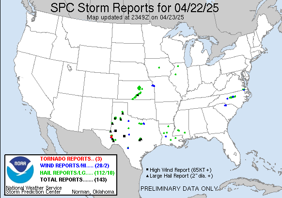 eekend. As the upper level system that brought us a few thunderstorms Friday night lifted into the Midwest Saturday and Sunday and met up with an environment ripe with moisture, unfortunately storms ravaged much of the Midwest. The graphic on the right is from the Storm Predicition Center and is a list of reported severe weather across the country for April 2. Click here to see the graphic on the Storm Predicition Center's website. Unfortunately, this is just the beginning of severe weather season across the country. Another system moving into the Central Plains and Midwest by Friday could bring the area another chance for severe weather.
Monday Morning Update
From Meteorologist Brandon Rector...
We began this morning mild with temperatures in the low 50s across the area. A cold front moved through the morning, so temperatures will not be as warm today as they were yesterday. Highs should be in the mid to upper 70s. Winds could be a bit breezy at times from the northeast at 10 to 15 mph.
A trough, or dip in the jetstream, looks to set up to our west for Tuesday through Thursday. An upper level low in the trough could send a few upper level disturbances our way on Tuesday and Wednesday. The upper level low looks to move over the central plains on Thursday. Most of the dynamics needed for showers and thunderstorms are expected to be too far to our north, but an isolated shower or thunderstorm can't be completely ruled out during these three days. I think our northern counties have the best chance of seeing the rain, if we have anything at all. That chance for rain is only slight right now. Highs will be in the mid 70s on Tuesday and the low to mid 80s on Wednesday and Thursday.
Friday through Sunday look nice with mostly sunny skies and highs ranging from the upper 70s to mid 80s.
Have a magnificent Monday!
We began this morning mild with temperatures in the low 50s across the area. A cold front moved through the morning, so temperatures will not be as warm today as they were yesterday. Highs should be in the mid to upper 70s. Winds could be a bit breezy at times from the northeast at 10 to 15 mph.
A trough, or dip in the jetstream, looks to set up to our west for Tuesday through Thursday. An upper level low in the trough could send a few upper level disturbances our way on Tuesday and Wednesday. The upper level low looks to move over the central plains on Thursday. Most of the dynamics needed for showers and thunderstorms are expected to be too far to our north, but an isolated shower or thunderstorm can't be completely ruled out during these three days. I think our northern counties have the best chance of seeing the rain, if we have anything at all. That chance for rain is only slight right now. Highs will be in the mid 70s on Tuesday and the low to mid 80s on Wednesday and Thursday.
Friday through Sunday look nice with mostly sunny skies and highs ranging from the upper 70s to mid 80s.
Have a magnificent Monday!
Saturday, April 01, 2006
Early Saturday Morning Discussion
From Chief Meteorologist Craig Carnesi...
After watching strong thunderstorms push from Scurry county to the East-Northeast and through Stonewall, Haskell and Knox counties, I thought I'd post new thoughts on Saturday's forecast.
It looks like we could be set-up for a significant severe weather outbreak anywhere from areas at or North of IH-20 all the way to Oklahoma City. There is no lack of moisture and no lack of instability. The only think lacking will be a lifting mechanism, or trigger. That will come by early afternoon I think in the form a a dryline. This will create the strong lift for VERY quickly developing thunderstorms.
There is significant reason to worry about tornados North of IH-20 tomorrow. The best chance for tornadic activity will be just North of our viewing area, but I don't think we are out of the woods.
Please use extreme caution if you have outdoor plans Saturday. Keep your weather radio turned on, your television turned on, and if you haven't yet, sign up for our free E-Warn service to get all weather watches and warnings sent to you.
Images below are courtesy of Accuweather.com.

After watching strong thunderstorms push from Scurry county to the East-Northeast and through Stonewall, Haskell and Knox counties, I thought I'd post new thoughts on Saturday's forecast.
It looks like we could be set-up for a significant severe weather outbreak anywhere from areas at or North of IH-20 all the way to Oklahoma City. There is no lack of moisture and no lack of instability. The only think lacking will be a lifting mechanism, or trigger. That will come by early afternoon I think in the form a a dryline. This will create the strong lift for VERY quickly developing thunderstorms.
There is significant reason to worry about tornados North of IH-20 tomorrow. The best chance for tornadic activity will be just North of our viewing area, but I don't think we are out of the woods.
Please use extreme caution if you have outdoor plans Saturday. Keep your weather radio turned on, your television turned on, and if you haven't yet, sign up for our free E-Warn service to get all weather watches and warnings sent to you.
Images below are courtesy of Accuweather.com.


Subscribe to:
Posts (Atom)